CBSE Geography Chapter 3 Interior of the Earth class 11 Notes Geography in PDF are available for free download in myCBSEguide mobile app. The best app for CBSE students now provides Interior of the Earth class 11 Notes Geography latest chapter wise notes for quick preparation of CBSE exams and school based annual examinations. Class 11 Geography notes on Chapter 3 Interior of the Earth class 11 Notes Geography are also available for download in CBSE Guide website.
CBSE Guide Interior of the Earth class 11 Notes
CBSE guide notes are the comprehensive notes which covers the latest syllabus of CBSE and NCERT. It includes all the topics given in NCERT class 11 Geography text book. Users can download CBSE guide quick revision notes from myCBSEguide mobile app and my CBSE guide website.
Interior of the Earth class 11 Notes Geography
Download CBSE class 11th revision notes for Chapter 3 Interior of the Earth class 11 Notes Geography in PDF format for free. Download revision notes for Interior of the Earth class 11 Notes Geography and score high in exams. These are the Interior of the Earth class 11 Notes Geography prepared by team of expert teachers. The revision notes help you revise the whole chapter in minutes. Revising notes in exam days is on of the best tips recommended by teachers during exam days.
Download Revision Notes as PDF
CHAPTER-3
Interior of the Earth class 11 Notes Geography
This chapter deals with
1. Sources of information of about the earth interior
2. direct sources
3. Indirect sources
4. earth quake
5. Earth quake waves
6. Propagation of earthquake waves
7. emergence of shadow zone
8. types of earthquakes
9. effects of earthquakes
10. structure of the earth
11. the crust
12. The mantle
13. the core
14. volcanoes and volcanic landforms
15. types of volcanoes
16. shield volcano
17. composite volcanoes
18. caldera
19. flood basalt provinces
20. mid ocean ridge volcanoes
21. volcanic landforms intrusive forms, plutonic rocks, batholiths, laccoliths, lapolith, phacolith ,sills & dykes
Sources of Information about the Earth’s Interior
¦ There are two sources for information about interior of the earth – a) Direct Sources and b) Indirect Sources:
¦ Direct Sources: Mining, drilling and volcanic eruption are examples of direct sources. During the process of mining and drilling rocks and minerals are extracted which gives information that there are layer system in the crust. Crust is made of many kinds of rocks and minerals. Volcanic eruption suggests that there is some zone inside the earth which is very hot and in liquid condition. Direct sources are not very reliable because mining and drilling can be done only up to some depth only.
¦ Indirect Sources: Seismic waves, gravitational field, magnetic field, falling meteors etc are example of indirect sources. They are very important for know about earth’s interior. Movement of seismic wave suggests that there are three layers in the earth and each layer has different density. Density increases toward the center of the earth.
Movement of seismic wave suggests two things: a) There are three layers in the earth and b) Each layer has different density which increases toward the center of the earth.
EARTH QUAKE
It is the shaking of the earth, natural event. It is caused due to release of energy which generates waves that travel to all directions.
WHY DOES EARTH SHAKE?
The release of energy occurs along the fault line
Rocks along the fault tend to move in opposite directions as the overlying strata press them the friction locks them together.
However, the tendency of movement overcome the friction
As a result, blocks get deformed
They slide over another: as a result energy releases.
Energy waves travel in all directions.
The point where energy releases is called focus/hypocenter Above the focus point on the surface it is called epicenter
EARTH QUAKE WAVES
All earth quakes take place in the lithosphere (200 km depth)
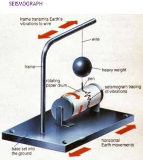
An instrument called Seismograph records the waves.
Earthquake and Seismic Waves
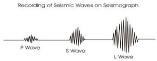
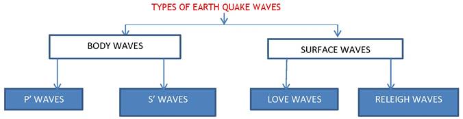
Meaning of Earthquake: Sudden movement or vibration on the earth surface is called earthquake. In other words, sudden release of energy due to tectonic activity is called earthquake. An earthquake may be produced due to: a) movement of plates, b) rising of magma, c) folding and faulting, d) violent volcanic eruption etc. When earthquake occurs, three types of wave are produced called as seismic waves. These are: a) P or Primary Wave, b) S or Secondary Wave, and c) L or Long or Surface Wave.
¦ P and S waves are combinely called as ‘Body Wave’ as they move inside the body of the earth.
¦ P wave is the fastest wave. It is also called as longitudinal wave. These waves move forth and back. In other words, P waves move parallel to the direction of wave. These waves can move in both solid and liquid.
¦ S wave is slower than P wave. It is also called as transverse wave. It moves perpendicular to the direction of the wave. These waves move only in solid and disappear in liquid.
¦ L wave is the slowest wave. It moves on the earth surface. It causes maximum destruction on the earth surface.
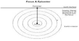
¦ Focus: It is point inside the earth surface from where an earthquake starts. It is always hidden inside the earth. Focus of an earthquake may be found at the depth of 100-200 km.
¦ Epicenter: It is a point on the earth surface which records the seismic waves for the first time. Maximum destruction from an earthquake is caused on the epicenter. Epicenter is located just perpendicular to the focus.
¦ P and S waves are called as Body Wave.
¦ P wave can pass through both solid and liquid. But S wave can pass only through solid.
¦ Seismograph: It is an instrument which record seismic waves on a paper.
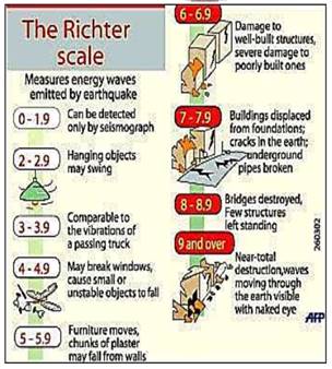
¦ Richter Scale: It is an scale which measures the magnitude of an earthquake. In other words, energy released by an earthquake is measured on Richter Scale. Generally, it is from 0 to 10. An earthquake measuring 6 on Richter Scale is 10 times more stronger than 5 and 100 times more stronger than 4.
¦ Crust and upper part of the mantle is called ‘lithosphere’.
¦ The opening through with magma comes out from a volcano is called as ‘mouth’ or ‘crater’. When crater is collapsed due to a violent explosion it is called as ‘caldera’.
¦ Mid-Oceanic Ridge: When plates move away from each other under the water of the ocean and magma rises up, it form a long hill like landform called as mid-oceanic ridge. Mid- oceanic ridge of Atlantic Ocean is the best example.
¦ Mercalli Scale: It was developed by an Italian seismologist. It measures the destruction caused by an earthquake. It ranges from 1 to 12.
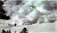
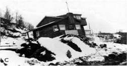
Effects of Earthquake
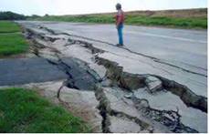
a) Ground shaking
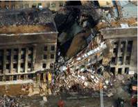
b) Destruction to houses and buildings
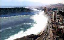
c) Land slide and tsunami
d) Soil liquefaction [solid soil becomes liquid]
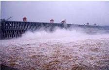
e) Damage to dams and reservoirs
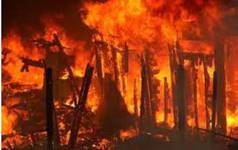
f) Fire accidents
g) Destruction to transport and communication lines.
Shadow Zones and Their Formation
Meaning of Shadow Zone: When earthquake takes place, all the places on the earth surface do not record the seismic waves. There are some zones where seismic waves [P and S waves] do not reach during an earthquake. It is called as shadow zone. Shadow zones are formed due to two reasons:
a) Three layers in the earth
b) Varying density of each layer
c) Liquid condition of the mantle
• P Wave Shadow Zone: Ideally seismic waves should move in straight line but due to varying density of layer P wave moves in a curved path. Due to this an area around the earth does not record P wave. This zone is from 1050 to 1450 from the focus.
• S Wave Shadow Zone: It is larger zone than P wave shadow zone. It developed because S wave does not pass through liquid mantle of the earth. Therefore, the zone from 1050 all around the earth from the focus is called as S wave shadow zone.
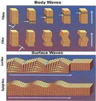
BODY WAVES GENERATED DUE TO ENERGY GENERATED IN THE EARTH’S INTERIOR
They interact with the surface rocks and generate other waves called surface waves The velocity of the waves changes along with the density of material, denser the material higher the velocity
Their direction also changes according to the density of the material
PROPAGATION OF EARTHQUAKE WAVES
When they travel in the body they vibrate the bodies of the rocks P waves vibrate parallel to their direction of the movement
It led to the density difference in the material due to stretching and squeezing Other three waves vibrate perpendicular to their direction
They create troughs and crests over the surface
EMERGENCE OF SHADOW ZONE
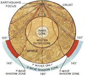
Where earthquake waves are not reported, such zones are called earthquake shadow zones.
It is observed that seismographs located beyond 103° from the epicenter do not record the earthquakes.
Seismographs located beyond 142° again record ‘p’ waves only.
The entire zone beyond 142° do not receive ‘s’ waves
The shadow zone of ‘s’ waves is much larger than the ‘p’ waves it is equal to 40% of the earth surface
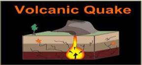
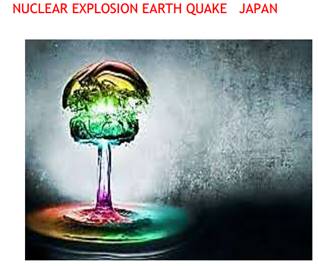
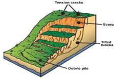
TYPES OF EARTHQUAKES
(INDONE)
(MINING EARTH QUAKE – SOUTH AFRI)
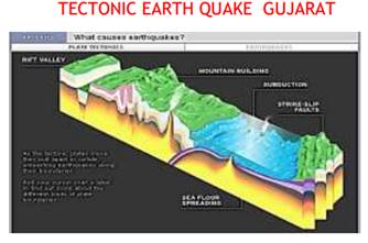
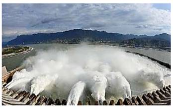
RESERVOIR IMPOUND EARTHQUAKE TEHRI DAM

HOW IS EARTH QUAKE MEASURED-RICHTER SCALE
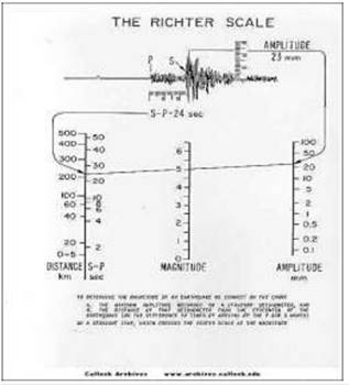
The magnitude of most earthquakes is measured on the Richter scale, invented by Charles F. Richter in 1934. The Richter magnitude is calculated from the amplitude of the largest seismic wave recorded for the earthquake, no matter what type of wave was the strongest.
The Richter magnitudes are based on a logarithmic scale (base 10). What this means is that for each whole number you go up on the Richter scale, the amplitude of the ground motion recorded by a seismograph goes up ten times. Using this scale, a magnitude 5 earthquake would result in ten times the level of ground shaking as a magnitude 4 earthquake (and 32 times as much energy would be released). To give you an idea how these numbers can add up, think of it in terms of the energy released by explosives: a magnitude 1 seismic wave releases as much energy as blowing up 6 ounces of TNT. A magnitude 8 earthquake releases as much energy as detonating 6 million tons of TNT. Pretty impressive, huh? Fortunately, most of the earthquakes that occur each year are magnitude 2.5 or less, too small to be felt by most people.
The Richter magnitude scale can be used to describe earthquakes so small that they are expressed in negative numbers. The scale also has no upper limit, so it can describe earthquakes of unimaginable and (so far) inexperienced intensity, such as magnitude 10.0 and beyond.
Although Richter originally proposed this way of measuring an earthquake’s “size,” he only used a certain type of seismograph and measured shallow earthquakes in Southern California. Scientists have now made other “magnitude” scales, all calibrated to Richter’s original method, to use a variety of seismographs and measure the depths of earthquakes of all sizes.
The Mercalli Scale
Here’s a table describing the magnitudes of earthquakes, their effects, and the estimated number of those earthquakes that occur each year.

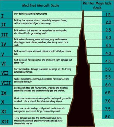
First six listed above have some hearings upon landforms while others may be considered the effects causing immediate concern to the life and properties of people in the region.
Tsunami occurs when the epicenter is below the ocean floor with sufficient magnitude. Tsunamis are waves generated by the termers not by the earthquake. The magnitude should be more than 5 in Richter scale.
The earthquakes of magnitude 8+ are rare occurs once in 1 -2 years .tiny types occur every minute. The structure of the Earth
Imagine a Scotch egg
1. The outer shell of the Earth is called the CRUST (breadcrumbs)
2. The next layer is called the MANTLE (sausage meat)
3. The next layer is the liquid OUTER CORE (egg white)
4. The middle bit is called the solid INNER CORE (egg yolk)
The deepest anyone has drilled into the earth is around 12 kilometers, we’ve only scratched the surface. How do we know what’s going on deep underground?
There are lots of clues:
1 .The overall density of the Earth is much higher than the density of the rocks we find in the crust. This tells us that the inside must be made of something much denser than rock.
2. Meteorites (created at the same time as the Earth, 4.6 billion years ago) have been analyzed. The commonest type is called a contrite and they contain iron, silicon, magnesium and oxygen (Others contain iron and nickel). A meteorite has roughly the same density as the whole earth. A meteorite minus its iron has a density roughly the same as Mantle rock (e.g. the mineral called olivine).
3. Iron and Nickel are both dense and magnetic.
4. Scientists can follow the path of seismic waves from earthquakes as they travel through the Earth. The inner core of the Earth appears to be solid whilst the outer core is liquid (s waves do not travel through liquids). The mantle is mainly solid as it is under extreme pressure (see below). We know that the mantle rocks are under extreme pressure, diamond is made from carbon deposits and is created in rocks that come from depths of 150-300 kilometers that have been squeezed under massive pressures.
5. The Earth is sphere (as is the scotch egg!) with a diameter of about 12,700 Kilometers. As we go deeper and deeper into the earth the temperature and pressure rises. The core temperature is believed to be an incredible 5000-6000°c.
6. The crust is very thin (average 20Km). This does not sound very thin but if you were to imagine the Earth as a football, the crust would be about ½ millimeter thick. The thinnest parts are under the oceans (OCEANIC CRUST) and go to a depth of roughly 10 kilometers.
The thickest parts are the continents (CONTINENTAL CRUST) which extend down to 35 kilometers on average. The continental crust in the Himalayas is some 75 kilometers deep.
7. The mantle is the layer beneath the crust which extends about half way to the centre. It’s made of solid rock and behaves like an extremely viscous liquid – (This is the tricky bit… the mantle is a solid which flows????) The convection of heat from the center of the Earth is what ultimately drives the movement of the tectonic plates and cause mountains to rise. Click here for more details
The outer core is the layer beneath the mantle. It is made of liquid iron and nickel. Complex convection currents give rise to a dynamo effect which is responsible for the Earth’s magnetic field.
8. The inner core is the bit in the middle!. It is made of solid iron and nickel. Temperatures in the core are thought to be in the region of 5000- 6000° c and it’s solid due to the massive pressure.
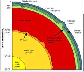
The mantle
1. Second layer from the top of the earth
2. 2. it extends from Moho-discontinuity to a depth of 2900 km.
3. 3. the upper portion of the mantle is called ASTHENOSPHERE ( Astheno= weak it extends up to 400 km)
4. 4. it is the source of magma
5. average density is 3.4g/cm3
6. 6. crust and upper most part of the mantle is called Lithosphere. Its thickness is 10 -200km
7. 7. Lower mantle is in solid state
The core
1. It extends from 2900 km to 6300 km depth
2. 2. Outer core is liquid while inner core is solid
3. 3. outer core density is 5 g/ inner core is 13 g/
4. made of heavy metals such as Nickel and Iron
5. it is also called as Nife
VOLCANOES AND VOLCANIC LANDFORMS
A volcano is place where gases, ashes and or molten rock material lava escape to the ground.
Active volcano Mount Pinatubo, Philippines in 1991.
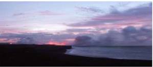
Lava from Mt. Kilauea pouring into the ocean during the sunset
The Differences between Active, Dormant and Extinct volcanoes
Active Volcano: Is a volcano that is currently erupting or shows signs of unrest activities, like earthquake activity or significant amounts of gas discharged. It is a volcano that is not presently erupting, but has erupted in the past is considered likely to do erupt in the future again.
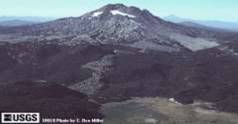
One of the dormant volcanoes in the Cascades in the “Three Sister Area.”
Dormant: These volcanoes are also called “Sleeping” volcanoes because it is presently inactive, but could erupt again. For example, the majority of the Cascade volcanoes arebelieved to be dormant rather than extinct.

Extinct: Is a volcano that is presently not erupting, that is unlikely to do so for a very long time in the future.
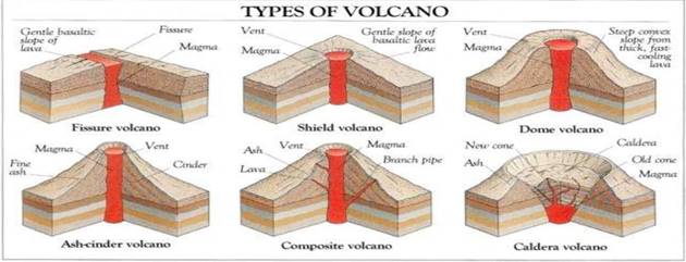
Classification of volcanoes based on nature of eruption and land forms developed on the surface. SHIELD VOLCANO
1. Largest of volcanoes
2. Hawaiian islands are best examples
3. Basalt lava flow
4. Lava is very fluid
5. They are not steep
6. They become explosive when water is held in tovent
7. Develops in to cinder cone
COMPOSITE VOLCANOES
1 Cool and more viscous lava
2. Explosive eruptions
3. They erupt pyroclasitc and ashes along with lava
4. Layers are formed
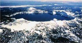
CALDERA
1 .These are the most explosive type of volcanoes

FLOOD BASALT PROVINCES
1. Consists of highly fluid lava
2. Some parts of the world are covered by thousands of sq.km of basalt
3. there can be series of flows
4. Average thickness is more than 50 km
5. Individual flow is 100 of sq.k.m
6. Ex. Deccan plateau
MID OCEANIC RIDGES VOLCANOES
1. Found in oceanic surfaces
2. More than 70,000 km length
3. Frequent volcanic eruptions
4. Ex. Mid Atlantic ridge
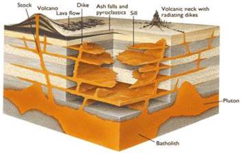
INTRUSIVE VOLCANIC LANDFORMS
1 .when volcanic eruption takes place some lava comes out and some settle down in the lithosphere.
2. when lava comes out forms volcanic rocks, some part cools down in the lower portion forms plutonic rocks
INTRUSIVE FORMS OCCUR INSIDE THE CRUST.
BATHOLITH: A large part of the magma material that cools in the deeper depthof the crust. They are dome shaped, cover large areas,
They come out when erosion takes place.they are granite bodies.
LACOLITHS: large dome shaped intrusive bodies. Consists of level bodies Connected through pipe like conduit from below it resembles composite volcanoes found deeper depthsthey are localised source of lava Ex. Karnataka plateau
LAPOLITHS: concave shaped lava formation phacoliths: wave typed lava formation
SILL: horizontal sheet of lava
DYKES: vertical lava formation
Interior of the Earth class 11 Notes
- CBSE Revision notes (PDF Download) Free
- CBSE Revision notes for Class 11 Geography PDF
- CBSE Revision notes Class 11 Geography – CBSE
- CBSE Revisions notes and Key Points Class 11 Geography
- Summary of the NCERT books all chapters in Geography class 11
- Short notes for CBSE class 11th Geography
- Key notes and chapter summary of Geography class 11
- Quick revision notes for CBSE exams
CBSE Class-11 Revision Notes and Key Points
Interior of the Earth class 11 Notes Geography. CBSE quick revision note for class-11 Mathematics, Physics, Chemistry, Biology and other subject are very helpful to revise the whole syllabus during exam days. The revision notes covers all important formulas and concepts given in the chapter. Even if you wish to have an overview of a chapter, quick revision notes are here to do if for you. These notes will certainly save your time during stressful exam days.
- Revision Notes for class-11 Physics
- Revision Notes for class-11 Chemistry
- Revision Notes for class-11 Mathematics
- Revision Notes for class-11 Biology
- Revision Notes for class-11 Accountancy
- Revision Notes for class-11 Economics
- Revision Notes for class-11 Business Studies
- Revision Notes for class-11 Computer Science
- Revision Notes for class-11 Informatics Practices
- Revision Notes for class-11 Geography
To download Interior of the Earth class 11 Notes, sample paper for class 11 Chemistry, Physics, Biology, History, Political Science, Economics, Geography, Computer Science, Home Science, Accountancy, Business Studies and Home Science; do check myCBSEguide app or website. myCBSEguide provides sample papers with solution, test papers for chapter-wise practice, NCERT solutions, NCERT Exemplar solutions, quick revision notes for ready reference, CBSE guess papers and CBSE important question papers. Sample Paper all are made available through the best app for CBSE students and myCBSEguide website.
- India – Location class 11 Notes Geography
- Structure and Physiography class 11 Notes Geography
- Drainage System class 11 Notes Geography
- Climate Vegetations and Soil class 11 Notes Geography
- Natural Vegetation class 11 Notes Geography
- Soils class 11 Notes Geography
- Geography as a Discipline class 11 Notes Geography
- Interior of the Earth class 11 Notes Geography
- Distribution of Oceans and Continent class 11 Notes Geography
- Minerals and Rocks class 11 Notes Geography
- Geomorphic Processes class 11 Notes Geography
- Landforms and their Evolution class 11 Notes Geography
- Solar Radiation, Heat Balance and Temperature class 11 Notes Geography
- Atmospheric Circulation and Weather System class 11 Notes Geography
- Water in the Atmosphere class 11 Notes Geography
- World Climate and Climate Change class 11 Notes Geography
- Water oceans class 11 Notes Geography
- Movements of Ocean Water class 11 Notes Geography
- Life on the Earth class 11 Notes Geography
- Biodiversity and Conservation class 11 Notes Geography
- Natural Hazards and Disasters class 11 Notes Geography
- The Origin and Evolution of the Earth class 11 Notes Geography
- Climate class 11 Notes Geography
Test Generator
Create question paper PDF and online tests with your own name & logo in minutes.
Create Now
Learn8 App
Practice unlimited questions for Entrance tests & government job exams at ₹99 only
Install Now