CBSE Geography Chapter 4 Distribution of Oceans and Continent class 11 Notes Geography in PDF are available for free download in myCBSEguide mobile app. The best app for CBSE students now provides Distribution of Oceans and Continent class 11 Notes Geography latest chapter wise notes for quick preparation of CBSE exams and school based annual examinations. Class 11 Geography notes on Chapter 4 Distribution of Oceans and Continent class 11 Notes Geography are also available for download in CBSE Guide website.
CBSE Guide Distribution of Oceans and Continent class 11 Notes
CBSE guide notes are the comprehensive notes which covers the latest syllabus of CBSE and NCERT. It includes all the topics given in NCERT class 11 Geography text book. Users can download CBSE guide quick revision notes from myCBSEguide mobile app and my CBSE guide website.
Distribution of Oceans and Continent class 11 Notes Geography
Download CBSE class 11th revision notes for Chapter 4 Distribution of Oceans and Continent class 11 Notes Geography in PDF format for free. Download revision notes for Distribution of Oceans and Continent class 11 Notes Geography and score high in exams. These are the Distribution of Oceans and Continent class 11 Notes Geography prepared by team of expert teachers. The revision notes help you revise the whole chapter in minutes. Revising notes in exam days is on of the best tips recommended by teachers during exam days.
Download Revision Notes as PDF
Chapter – 4
Distribution of Oceans and Continent class 11 Notes Geography
GIST OF THE LESSON: CONTINENTAL DRIFT, EVIDENCES TO SUPPORT CONTINENTAL DRIFT, FORCES OF DRIFTING, POST DRIFT STUDIES, OCEAN FLOOR CONFIGURATION, DISTRIBUTION OF VOLCANOES AND EARTHQUAKES, CONCEPT OF SEA FLOOR SPREADING, PLATE TECTONICS, MAJOR AND MINOR PLATES, TYPES OF PATE BOUNDARIES RATES OF PLATE MOVEMENT, FORCES OF PLATE MOVEMENT& MOVEMENT OF THE INDIAN PLATE.
CONTINENTAL DRIFT: ABRAHAM ORTELIUS a Duchy map maker 1596 first proposed the possibility of joining the continents such as America with Europe and Africa ANTONIO PELLEGRINI drew the map showing the three continents together.
ALFRED WEGENER a German meteorologist put forth THE CONTINENTAL DRIFT THEORY. According to him,
All continents formed a single continental mass called PANGAEA
All oceans formed a single universal ocean called PANTHALASSA
AROUND 200 mya THE PANGAEA BEGAN TO SPLIT INTO TWO LARGE MASSES CALLED LAURASIA and GONDWANA LAND
By further splitting Laurasia formed northern continents and Gondwana land formed southern continents.
EVIDENCES TO SUPPORT THE CONTINENTAL DRIFT
1. The matching of continents (jig-saw fit)
A. the shorelines of S. America and Africa have remarkable match
B. a map was produced by Bullard in 1964 to show the jigsaw fit of these two continents.
C. it was fit around 1000 fathom line of the shoreline
2. ROCKS OF SAME AGE ACROSS THE OCEANS
A. the belt of ancient rocks of 2000 my from Brazil coast matches with those of Western Africa
B. Marine deposits of South America and Africa belong to Jurassic age.
3. TILLITE
A. sedimentary rock formed out of glacial deposits
B. sediments from India have similar counter parts at different continents of south.
C. tillile indicates prolonged glaciations
D. The same glaciations is found in Africa, Falklands, Madagascar, Antarctica and Australia
E. the glacial tillite indicates that unambiguous evidence of palaeo climates and drifting of continents.
4. PLACER DEPOSITS
a. Formation of placer deposits of gold in Ghana coast has no source rock.
a. The gold bearing veins of rocks are found in Brazil
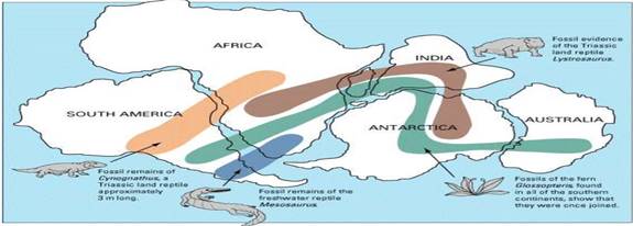
5. DISTRIBUTION OF FOSSILS
• Identical species of animals and plants are found along the coastal regions of the different continents.
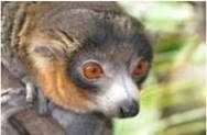
• lemurs occurs in India, Madagascar and Africa.
• The contiguous Land mass was called LEMURIA
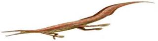
• the fossils of mesosaurus were found in only South Africa and Brazil.
LEMURIA
MESOSAURUS
DISTRIBUTION OF FOSSILS
FORCES FOR DRIFTING THE CONTINENTS
1. Wegner suggested that the movement responsible for the drifting of the continents was caused by
A. POLAR FLEEING FORCE B. TIDAL FORCE
Possible driving forces for plate tectonics:
2. bottom lithosphere tractions by convection currents.
3. trench pull (covered earlier).
4. ridge push (sliding off a high, crust in compression).
5. trench suck (rollback).
6. global expanding or contracting forces.
7. membrane forces on spinning ellipsoid (e.g. variants of polar fleeing forces).
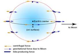
TIDAL FORCE
Wegener suggested that these two forces are responsible for the movement of plates.
Most of the scholars consider that these forces are not sufficient to move the plates.
POST DRIFT STUDIES
Information collected from the ocean mapping is more useful to study the continental drift
Convectional current theory
It was proposed by ARTHUR HOLMES IN 1930 Due to difference in the temperature currents are formed due to disintegration of radioactive materials inside the earth.
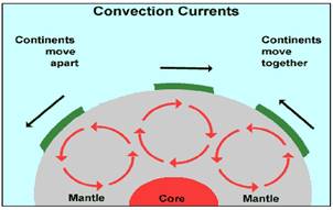
These currents are found entire mantle portion
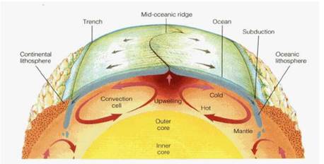
MAPPING OCEAN FLOOR
1. Existence of ridges and deep trenches nearby continental margins
2. Mid oceanic ridge is the most active for volcanic eruptions
3. The ocean floor is much younger than the continents
4. Rocks of equal distance of the ridge have similar chemical composition and age
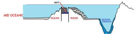
OCEAN FLOOR CONFIGURATION
The ocean floor is segmented into three major divisions Based on depth and configuration
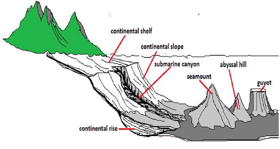
1. Continental margins
a. Form transitional zone between continental shore and deep sea basins
b. They include continental slope, shelf, continental rise and deep oceanic trenches ABYSSAL PLAINS
1. EXTENSIVE PLAINS
2. FOUND BETWEEN CONTINENTAL MARIGN AND MID OCEANIC RIDGE
3. CONTINENTAL SEDIMENTS GET DEPOSITED
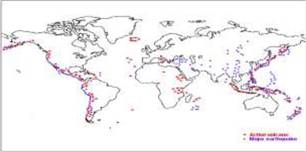
DISTRIBUTION OF VOLCANOES AND EARTHQUAKES
1. all volcanoes and earthquakes are paralle to the coast
2. this line also coinsides with mid- atalantic ridge
3. alpine hymalayan system
4. around the pacific ocean it is called ring of fire Mid oceanic ridges
1. Interconnected mountain system within the ocean
2. Longest mountain chain in the ocean floor
3. Consist of central rift system at the crust
4. Intense volcanic activity is found
CONCEPT OF SEA FLOOR SPREADING
1 .it was proposed by Hess in 1961
2. he believed that new lava pushes out the plates from the mid oceanic ridge
3. palaeo magnetic studies of the ocean floor reveals that
A. along the mid oceanic ridge there is intense volcanic eruption
B. huge amount of lava comes out along the mid atlanticn ridges
C. the equidistant rock formations have similar age and chemical compositions & magnetic properties
7. rocks closer to the mid oceanic ridges are young and normal polarity
8. The age of rocks increases as the distance increases from the mid oceanic ridge
9. Oceanic crust is much younger(200my) than continental crust (3200my)
10. The sediments of ocean floor is very thisn
11. earth quakes are common along the deep sea trenches Positions of continents through geological past
PLATE TECTONICS
1. The theory of plate tectonics was introduced by McKenzie, parker and Morgan in 1967
2. A tectonic plate is also called as lithosphere plate
3. It is a massive irregularly shaped slab of solid rock
4. Consists of oceanic and continental sphere
5. Plates move horizontally over the Asthenosphere
6. Average thickness is 100 km of oceanic part and 200 km continental part
7. It may be oceanic or continental
8. Pacific plate is largest oceanic plate where as Eurasian plate is the largest continental plate
MAJOR PLATES OF THE EARTH CRUST
MAJORPLATES
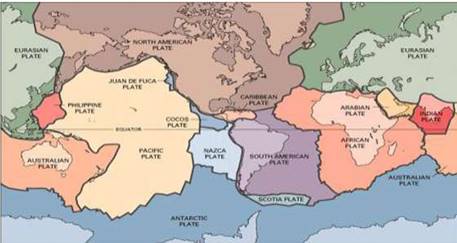
MAJOR PLATES

1. Antarctica And Surrounding Oceanic
Plate 2. North American Plate
3. South American Plate Pacific Plate India-Australia-New Zealand PLATE
6.African Plate Eurasian Plate
MINOR PLATES
1. Cocos
Plate 2. Nazca Plate 3. Arabian Plate 4. Philippine Plate 5. Caroline Plate 6. Fuji Plate
These plates are moving constantly throughout geological time not the continent believed by Wegener Pangaea was the convergent of all the plates
Position of Indian subcontinent is traced with the help of rocks analyzed from Nagpur area
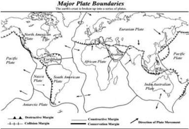
TYPES OF PLATE BOUNDARIES
I. DIVERGENT BOUNDARIES
1. New crust is generated 2. plates move away from each other
2. These are called spreading sites 3. Ex. Mid Atlantic ridge
II. CONVERGENT BOUNDARY
1. Crust is destroyed
2. sinking of plate is called ‘subduction zone’
3. There are three ways in which subduction occurs
i. Ocean and continent ii. Ocean and ocean iii. continent and continent plates
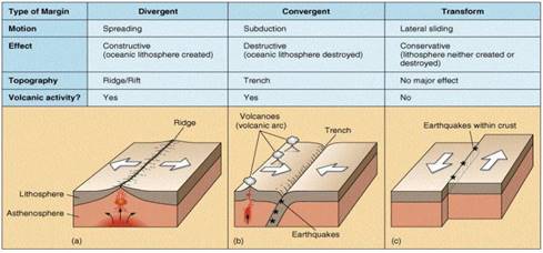
III TRANSFORM BOUNDARIES
1. Crust is neither produced nor destroyed
2. Plates slide horizontally
3. Perpendicular to the mid oceanic ridges
4. Differential movement of a plate at the same time
5. Rotation of the earth has its effect on this movement
RATES OF PLATE MOVEMENT
1. The strips of normal and reverse magnetic field helped the scientists to study the rate of plate movement
2. Arctic ridge has the slowest rate less than 2.5 cm /year east pacific rise has more than
3. 15 cm/year
FORCES OF THE PLATE MOVEMENT
1. Surface of the earth is dynamic
2. Interior is always mobile
3. Beneath the lithosphere there is always movement of magma horizontally
4. Heated material rises to the top and cooled material sinks down
5. This cycle is repeated over the time and form convection cells
SOURCES OF HEAT
A. Residual heat b. Radioactive decay
6. It was first considered by Arthur Holmes in 1930
7. Later it also influenced Harry Hess
MOVEMENT OF INDIAN PLATE
1. Indian plate includes India and Australia
2. Northern boundary is along the Himalayas
3. It is the place of continental convergence
4. In the east it extends up to Rakinyoma mountains of Myanmar
5. Eastern margin is spreading site
6. Western margin extends along Kirthar mountains, Makran coast red sea rift.
7. The boundary between India and Antarctica is called divergent boundary
8. Till 225 m y a India was separated by Tethys sea
9. About 200 m y a India started its journey towards north
10. India collided with Asia about 40-50 m y a and caused the upliftment of Himalayas
11. About 140 m y a the position of Indian plate is at 50°s latitude
12. During the movement of Indian plate two events occurred in India
13. A. out pouring of lava and formation of Deccan plateau
B. Subsidence of west coast
14. The Himalayas started rising about 40 m y a
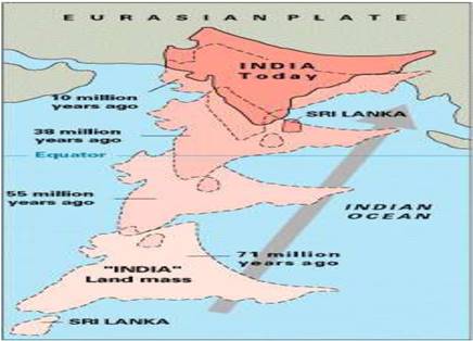
STAGES OF MOVEMENT OF INDIAN PLATE TO WARDS ASIAN PLATE AT DIFFERENT AGES
Distribution of Oceans and Continent class 11 Notes
- CBSE Revision notes (PDF Download) Free
- CBSE Revision notes for Class 11 Geography PDF
- CBSE Revision notes Class 11 Geography – CBSE
- CBSE Revisions notes and Key Points Class 11 Geography
- Summary of the NCERT books all chapters in Geography class 11
- Short notes for CBSE class 11th Geography
- Key notes and chapter summary of Geography class 11
- Quick revision notes for CBSE exams
CBSE Class-11 Revision Notes and Key Points
Distribution of Oceans and Continent class 11 Notes Geography. CBSE quick revision note for class-11 Mathematics, Physics, Chemistry, Biology and other subject are very helpful to revise the whole syllabus during exam days. The revision notes covers all important formulas and concepts given in the chapter. Even if you wish to have an overview of a chapter, quick revision notes are here to do if for you. These notes will certainly save your time during stressful exam days.
- Revision Notes for class-11 Physics
- Revision Notes for class-11 Chemistry
- Revision Notes for class-11 Mathematics
- Revision Notes for class-11 Biology
- Revision Notes for class-11 Accountancy
- Revision Notes for class-11 Economics
- Revision Notes for class-11 Business Studies
- Revision Notes for class-11 Computer Science
- Revision Notes for class-11 Informatics Practices
- Revision Notes for class-11 Geography
To download Distribution of Oceans and Continent class 11 Notes, sample paper for class 11 Chemistry, Physics, Biology, History, Political Science, Economics, Geography, Computer Science, Home Science, Accountancy, Business Studies and Home Science; do check myCBSEguide app or website. myCBSEguide provides sample papers with solution, test papers for chapter-wise practice, NCERT solutions, NCERT Exemplar solutions, quick revision notes for ready reference, CBSE guess papers and CBSE important question papers. Sample Paper all are made available through the best app for CBSE students and myCBSEguide website.
- India – Location class 11 Notes Geography
- Structure and Physiography class 11 Notes Geography
- Drainage System class 11 Notes Geography
- Climate Vegetations and Soil class 11 Notes Geography
- Natural Vegetation class 11 Notes Geography
- Soils class 11 Notes Geography
- Geography as a Discipline class 11 Notes Geography
- Interior of the Earth class 11 Notes Geography
- Distribution of Oceans and Continent class 11 Notes Geography
- Minerals and Rocks class 11 Notes Geography
- Geomorphic Processes class 11 Notes Geography
- Landforms and their Evolution class 11 Notes Geography
- Solar Radiation, Heat Balance and Temperature class 11 Notes Geography
- Atmospheric Circulation and Weather System class 11 Notes Geography
- Water in the Atmosphere class 11 Notes Geography
- World Climate and Climate Change class 11 Notes Geography
- Water oceans class 11 Notes Geography
- Movements of Ocean Water class 11 Notes Geography
- Life on the Earth class 11 Notes Geography
- Biodiversity and Conservation class 11 Notes Geography
- Natural Hazards and Disasters class 11 Notes Geography
- The Origin and Evolution of the Earth class 11 Notes Geography
- Climate class 11 Notes Geography
Test Generator
Create question paper PDF and online tests with your own name & logo in minutes.
Create Now
Learn8 App
Practice unlimited questions for Entrance tests & government job exams at ₹99 only
Install Now