CBSE Geography Chapter 3 Drainage System class 11 Notes Geography in PDF are available for free download in myCBSEguide mobile app. The best app for CBSE students now provides Drainage System class 11 Notes Geography latest chapter wise notes for quick preparation of CBSE exams and school based annual examinations. Class 11 Geography notes on Chapter 3 Drainage System class 11 Notes Geography are also available for download in CBSE Guide website.
CBSE Guide Drainage System class 11 Notes
CBSE guide notes are the comprehensive notes which covers the latest syllabus of CBSE and NCERT. It includes all the topics given in NCERT class 11 Geography text book. Users can download CBSE guide quick revision notes from myCBSEguide mobile app and my CBSE guide website.
Drainage System class 11 Notes Geography
Download CBSE class 11th revision notes for Chapter 3 Drainage System class 11 Notes Geography in PDF format for free. Download revision notes for Drainage System class 11 Notes Geography and score high in exams. These are the Drainage System class 11 Notes Geography prepared by team of expert teachers. The revision notes help you revise the whole chapter in minutes. Revising notes in exam days is on of the best tips recommended by teachers during exam days.
Download Revision Notes as PDF
CHAPTER -3
Drainage System class 11 Notes Geography
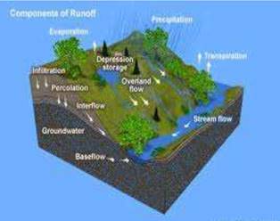
The flow of water through well-defined channels is known as ‘drainage’
The network of such channels is called a ‘drainage system’.
The drainage pattern of an area is the outcome of the geological time period, nature and structure of rocks, topography, slope, amount of water flowing and the periodicity of the flow.
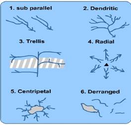
Drainage system Important Drainage Patterns
(i) The drainage pattern resembling the branches of a tree is known as “dendritic” the examples of which are the rivers of northern plain.
(ii) When the rivers originate from a hill and flow in all directions, the drainage pattern is Known as ‘radial’. The rivers originating from the Amarkantak range present a good example of it.
(iii) When the primary tributaries of rivers flow parallel to each other and secondary tributaries join them at right angles, the pattern is known as ‘trellis’.
(iv) When the rivers discharge their waters from all directions in a lake or depression, the pattern is know as ‘centripetal’.
The boundary line separating one drainage basin from the other is known as the watershed.
The catchments of large rivers are called river basins while those of small rivulets and rills are often referred to as watersheds.

There is, however, a slight difference between a river basin and a watershed. Watersheds are small in area while the basins cover larger areas.
They are accepted as the most appropriate micro, meso or macro planning regions.
Indian drainage system may be divided on various bases.
On the basis of discharge of water (orientations to the sea), it may be grouped into:
(i) the Arabian Sea drainage; and
(ii) the Bay of Bengal drainage.
They are separated from each other through the Delhi ridge, the Aravalis and the Sahyadris (water divide is shown by a line in Figure 3.1). river basin
77 per cent of the drainage area consisting of the Ganga, the Brahmaputra, the Mahanadi, the Krishna, etc. is oriented towards the Bay of Bengal
23 percent comprising the Indus, the Narmada, the Tapi, the Mahi and the Periyar systems discharge their waters in the Arabian Sea.
On the basis of the size of the watershed,
the drainage basins of India are grouped into three categories:
(i) Major river basins with more than 20,000 sq. km of catchment area. It includes 14 drainage basins such as the Ganga, the Brahmaputra, the Krishna, the Tapi, the Narmada, the Mahi, the Pennar, the Sabarmati, the Barak, etc.
(ii) Medium river basins with catchment area between 2,000-20,000 sq. km incorporating 44 river basins such as the Kalindi, the Periyar, the Meghna, etc.
(iii) Minor river basins with catchment area of less than 2,000 sq. km include fairly good number of rivers flowing in the area of low rainfall.
North Indian rivers are originating from Himalayas peninsular rivers are originating from Western ghats
The Narmada and Tapi are two large rivers which are exceptions originating form central highlands.
the Indian drainage may also be classified into the Himalayan drainage and the Peninsular drainage.
THE HIMALAYAN DRAINAGE
1. The Himalayan drainage system has a long geological history.
2. the important rivers are Ganga, the Indus and the Brahmaputra rivers.
3. Since these are fed both by melting of snow and precipitation, rivers of this system are perennial.
4. rivers form giant gorges V-shaped valleys, rapids and waterfalls in their mountainous course.
5. While entering the plains, they form depositional features like flat valleys, ox-bow lakes, flood plains,
EVOLUTION OF THE HIMALAYAN DRAINAGE
1. Geologists believe that a mighty river called Shiwalik or Indo-Brahma traversed the entire longitudinal extent of the Himalaya from Assam to Punjab and onwards to Sind, and finally discharged into the Gulf of Sind near lower Punjab during the Miocene period some 5-24 million years ago
2. The remarkable continuity of the Shiwalik and its lacustrine origin and alluvial deposits consisting of sands, silt, clay, boulders and conglomerates support this viewpoint. in due course of time Indo- Brahma river was dismembered into three main drainage systems:
(i) the Indus and its five tributaries in the western part;
(ii) the Ganga and its Himalayan tributaries in the central part; and
(iii) the stretch of the Brahmaputra in Assam and its Himalayan tributaries in the eastern part.
The dismemberment was probably due to the Pleistocene upheaval in the western Himalayas, including the uplift of the Potwar Plateau (Delhi Ridge), which acted as the water divide between the Indus and Ganga drainage systems.
Likewise, the down thrusting of the Malda gap area between the Rajmahal hills and the Meghalaya plateau during the mid-pleistocene period, diverted the Ganga and the Brahmaputra systems to flow Towards the Bay of Bengal.
THE RIVER SYSTEMSOFTHEHIMALAYAN DRAINAGE
The Indus System
1. It is one of the largest river basins of the world, covering an area of 11,65,000 sq. km (in India it is 321, 289 sq. km and a total length of 2,880 km (in India 1,114 km).
2. The Indus also known as the Sindhu, is the westernmost of the Himalayan rivers in India.
3. It originates from a glacier near Bokhar Chu (31 °15′ N latitude and 81 °40′ E longitude) in the Tibetan region at an altitude of 4,164 m in the Kailash Mountain range.
4. In Tibet, it is known as ‘Singi Khamban; or Lion’s mouth. After flowing in the northwest direction between the Ladakh and Zaskar ranges, it passes through Ladakh and Baltistan.
5.It cuts across the Ladakh range, forming a spectacular gorge near Gilgit in Jammu and Kashmir.
6. It enters into Pakistan near Chillar in the Dardistan region. Find out the area known as Dardistan.
7. tributaries such as the Shyok, the Gilgit, theZaskar, the Hunza, the Nubra, the Shigar, the Gasting and the Dras.
8. It finally emerges out ofthe hills near Attock where it receives the Kabul river on its right bank.
9. The other important tributaries joining the right bank of the Indus are the Khurram, the Tochi, the Gomal, the Viboa and the Sangar. They all originate in the Sulaiman ranges.
10. The river flows southward and receives ‘Panjnad’ a little above Mithankot. The Panjnad is the name given to the five rivers of Punjab, namely the Satluj, the Beas, the Ravi, the Chenab and the Jhelum.It finally discharges into the Arabian Sea, east of Karachi. The Indus flows in India only through the Leh district in Jammu and Kashmir.
The Ganga System
1. The Ganga is the most important river of India both from the point of view of its basin and cultural significance.
2. It rises in the Gangotri glacier near Gaumukh (3,900 m) in the Uttarkashi district of Uttarakhand.
3. Here, it is known as the Bhagirathi.
4. It cuts through the Central and the Lesser Himalayas in narrow gorges. At Devprayag, the Bhagirathi
5. meets the Alaknanda; hereafter, it is known as the Ganga.
6. The Alaknanda has its source in the Satopanth glacier above Badrinath. The Alaknanda consists of the Dhauli and the Vishnu Ganga which meet at Joshimath or Vishnu Prayag.
7. The other tributaries of Alaknanda such as the Pindar joins it at Karna Prayag while Mandakini or Kali Ganga meets it at Rudra Prayag.
8. The Ganga enters the plains at Haridwar. From here, it flows first to the south, then to the south-east and east before splitting into two distributaries, namely the Bhagirathi and the Hugli. The river has a length of 2,525 km. It is shared by Uttarakhand (110 km) and Uttar Pradesh (1,450 km), Bihar (445 km) and West Bengal (520 km).
9. The Ganga basin covers about 8.6 lakh sq. km area in India alone.
10. The Ganga river system is the largest in India having a number of perennial and nonperennial rivers originating in the Himalayas in the north and the Peninsula in the south, respectively.
11. The Son is its major right bank tributary.
12. The important left bank tributaries are the Ramganga, the Gomati, the Ghaghara, the Gandak, the Kosi and the Mahananda.
13. The river finally discharges itself into the Bay of Bengal near the Sagar Island.
The Brahmaputra System
1. The Brahmaputra, one of the largest rivers of the world, has its origin in the Chemayungdung glacier of the Kailash range near the Mansarovar lake.
2. From here, it traverses eastward longitudinally for a distance of nearly 1,200 km in a dry and flat region of southern Tibet, where it is known as the Tsangpo, which means ‘the purifier.’
3. The Rango Tsangpo is the major right bank tributary of this river in Tibet.
4. It emerges as a turbulent and dynamic river after carving out a deep gorge in the Central Himalayas near Namcha Barwa (7,755 m).
5. The river emerges from the foothills under the name of Siang or Dihang. It enters India west of Sadiya town in Arunachal Pradesh.
6. Flowing southwest, it receives its main left bank tributaries, viz., Dibang or Sikang and Lohit; thereafter, it is known as the Brahmaputra.
7. The Brahmaputra receives numerous tributaries in its 750 km long journey through the Assam valley.
8.Its major left bank tributaries are the Burhi Dihing and Dhansari (South) whereas the important right bank tributaries are the Subansiri, Kameng, Manas and Sankosh.
9. The Brahmaputra enters into Bangladesh near Dhubri and flows southward. In Bangladesh, the Tista joins it on its right bank from where the river is known as the Yamuna.
10. It finally merges with the river Padma, which falls in the Bay of Bengal. The Brahmaputra is well-known for floods, channel shifting and bank erosion.
11. This is due to the fact that most of its tributaries are large, and bring large quantity of sediments owing to heavy rainfall in its catchment area.
THE PENINSULAR DRAINAGE SYSTEM
1. The Peninsular drainage system is older than the Himalayan one.
2. This is evident from the broad, largely-graded shallow valleys, and the maturity of the rivers.
3. The Western Ghats running close to the western coast act as the water divide between the major Peninsular rivers, discharging their water in the Bay of Bengal and as small rivulets joining the Arabian Sea.
4. Most of the major Peninsular rivers except Narmada and Tapi flow from west to east.
5. The Chambal, the Sind, the Betwa, the Ken, the Son, originating in the northern part of the Peninsula belong to the Ganga river system. The other major river systems of the Peninsular drainage are – the Mahanadi the Godavari, the Krishna and the Kaveri.
6. Peninsular rivers are characterised by fixed course, absence of meanders and non -perennial flow of water.
7. The Narmada and the Tapi which flow through the rift valley are, however, exceptions.
The Evolution of Peninsular Drainage System
Three major geological events in the distant past have shaped the present drainage systems of Peninsular India:
(i) Subsidence of the western flank of the Peninsula leading to its submergence below the sea during the early tertiary period. Generally, it has disturbed the symmetrical plan of the river on either side of the original watershed.
(ii) Upheaval of the Himalayas when the northern flank of the Peninsular block was subjected to subsidence and the consequent trough faulting. The Narmada and The Tapi flow in trough faults and fill the original cracks with their detritus materials. Hence, there is a lack of alluvial and deltaic deposits in these rivers.
(iii) Slight tilting of the Peninsular block from northwest to the southeastern direction gave orientation to the entire drainage system towards the Bay of Bengal during the same period.
Table 3.1: Comparison between the Himalayan and the Peninsular River
| Sl. No. | Aspects | Himalayan River | Peninsular River |
| 1. | Place of origin | Himalayan mountain covered with glaciers | Peninsular plateau and central highland |
| 2. | Nature of flow | Perennial, receive water from glacier and rainfall | Seasonal: dependent on monsoon rainfall |
| 3. | Type of drainage | Antecedent and consequent leading to dentritic pattern in plains | Super imposed, rejuvenated resulting in trellis, radial and rectangular patterns |
| 4. | Nature of river | Long course, flowing through the rugged mountains experiencing headward erosion and river capturing In plains meandering and shifting of course | Smaller, fixed course with well-adjusted valleys |
| 5. | Catchment area | Very large basins | Relatively smaller basin |
| 6. | Age of the river | Young and Youthful, active and deepening in the valleys | Old rivers with graded profile, and have almost reached their base levels |
The River Regime
1. The pattern of flow of water in a river channel over a year is known as its regime.
2. The north Indian rivers originating from the Himalayas are perennial as they are fed by glaciers through snow melt and also receive rainfall water during rainy season.
3. The rivers of South India do not originate from glaciers and their flow pattern witnesses fluctuations.
4. The flow increases considerably during monsoon rains. Thus, the regime of the rivers of South India is controlled by rainfall which also varies from one part of the Peninsular plateau to the other.
5. The discharge is the volume of water flowing in a river measured over time. It is measured either in cusecs (cubic feet per second) or cumecs (cubic metres per second).
6. The Ganga has its minimum flow during the January-June period. The maximum flow is attained either in August or in September. After September, there is a steady fall in the flow. The river, thus, has a monsoon regime during the rainy season.
7. There are striking differences in the river regimes in the eastern and the western parts of the Ganga Basin.
8. The Ganga maintains a sizeable flow in the early part of summer due to snow melt before the monsoon rains begin. The mean maximum discharge of the Ganga at Farakka is about 55,000 cusecs while the mean minimum is only 1,300 cusecs.
What are the factors responsible for such a large difference?
EXTENT OF USABILITY OF RIVER WATER
River Water can be used in the following way
1. Construction of dams
2. Interlinking of rivers
3. Construction of check dams
4. Construction of canals parallel to the river
5. Lift irrigation
PROBLEMS OF RIVER WATER USABILITY
(i) No availability in sufficient quantity
(ii) River water pollution
(iii) Load of silt in the river water
(iv) Uneven seasonal flow of water
(v) River water disputes between states
(vi) Shrinking of channels due to the extension of settlements towards the thalweg
Why are the rivers polluted?
Have you seen the dirty waters of cities entering into the rivers?
Where do the industrial affluent and wastes get disposed of?
Most of the cremation grounds are on the banks of rivers and the dead bodies are sometimes thrown in the rivers. On the occasion of some festivals, the flowers and statues are immersed in the rivers. Large scale bathing and washing of clothes also pollute river waters.
How can the rivers be made pollution free?
Have you read about Ganga Action Plan, or about a campaign for cleaning the Yamuna at Delhi? Collect materials on schemes for making rivers pollution free and organise the materials into a write up.
Drainage System class 11 Notes
- CBSE Revision notes (PDF Download) Free
- CBSE Revision notes for Class 11 Geography PDF
- CBSE Revision notes Class 11 Geography – CBSE
- CBSE Revisions notes and Key Points Class 11 Geography
- Summary of the NCERT books all chapters in Geography class 11
- Short notes for CBSE class 11th Geography
- Key notes and chapter summary of Geography class 11
- Quick revision notes for CBSE exams
CBSE Class-11 Revision Notes and Key Points
Drainage System class 11 Notes Geography. CBSE quick revision note for class-11 Mathematics, Physics, Chemistry, Biology and other subject are very helpful to revise the whole syllabus during exam days. The revision notes covers all important formulas and concepts given in the chapter. Even if you wish to have an overview of a chapter, quick revision notes are here to do if for you. These notes will certainly save your time during stressful exam days.
- Revision Notes for class-11 Physics
- Revision Notes for class-11 Chemistry
- Revision Notes for class-11 Mathematics
- Revision Notes for class-11 Biology
- Revision Notes for class-11 Accountancy
- Revision Notes for class-11 Economics
- Revision Notes for class-11 Business Studies
- Revision Notes for class-11 Computer Science
- Revision Notes for class-11 Informatics Practices
- Revision Notes for class-11 Geography
To download Drainage System class 11 Notes, sample paper for class 11 Chemistry, Physics, Biology, History, Political Science, Economics, Geography, Computer Science, Home Science, Accountancy, Business Studies and Home Science; do check myCBSEguide app or website. myCBSEguide provides sample papers with solution, test papers for chapter-wise practice, NCERT solutions, NCERT Exemplar solutions, quick revision notes for ready reference, CBSE guess papers and CBSE important question papers. Sample Paper all are made available through the best app for CBSE students and myCBSEguide website.
- India – Location class 11 Notes Geography
- Structure and Physiography class 11 Notes Geography
- Drainage System class 11 Notes Geography
- Climate Vegetations and Soil class 11 Notes Geography
- Natural Vegetation class 11 Notes Geography
- Soils class 11 Notes Geography
- Geography as a Discipline class 11 Notes Geography
- Interior of the Earth class 11 Notes Geography
- Distribution of Oceans and Continent class 11 Notes Geography
- Minerals and Rocks class 11 Notes Geography
- Geomorphic Processes class 11 Notes Geography
- Landforms and their Evolution class 11 Notes Geography
- Solar Radiation, Heat Balance and Temperature class 11 Notes Geography
- Atmospheric Circulation and Weather System class 11 Notes Geography
- Water in the Atmosphere class 11 Notes Geography
- World Climate and Climate Change class 11 Notes Geography
- Water oceans class 11 Notes Geography
- Movements of Ocean Water class 11 Notes Geography
- Life on the Earth class 11 Notes Geography
- Biodiversity and Conservation class 11 Notes Geography
- Natural Hazards and Disasters class 11 Notes Geography
- The Origin and Evolution of the Earth class 11 Notes Geography
- Climate class 11 Notes Geography
Test Generator
Create question paper PDF and online tests with your own name & logo in minutes.
Create Now
Learn8 App
Practice unlimited questions for Entrance tests & government job exams at ₹99 only
Install Now