Solar Radiation Heat Balance and Temperature class 11 Notes Geography in PDF are available for free download in myCBSEguide mobile app. The best app for CBSE students now provides Solar Radiation, Heat Balance and Temperature class 11 Notes Geography latest chapter wise notes for quick preparation of CBSE exams and school based annual examinations. Class 11 Geography notes on Chapter 9 Solar Radiation, Heat Balance and Temperature class 11 Notes Geography are also available for download in CBSE Guide website.
Solar Radiation Heat Balance and Temperature class 11 Notes Geography
Download CBSE class 11th revision notes for Chapter 9 Solar Radiation, Heat Balance and Temperature class 11 Notes Geography in PDF format for free. Download revision notes for Solar Radiation, Heat Balance and Temperature class 11 Notes Geography and score high in exams. These are the Solar Radiation, Heat Balance and Temperature class 11 Notes Geography prepared by team of expert teachers. The revision notes help you revise the whole chapter in minutes. Revising notes in exam days is on of the best tips recommended by teachers during exam days.
CBSE guide notes are the comprehensive notes which covers the latest syllabus of CBSE and NCERT. It includes all the topics given in NCERT class 11 Geography textbook. Users can download CBSE guide quick revision notes from myCBSEguide mobile app and my CBSE guide website.
Download Revision Notes as PDF
CBSE Class 9 Revision Notes Geography Solar Radiation, Heat Balance and Temperature
This chapter deals with Solar radiation, variability of insolation at the surface of the earth heating and cooling of atmosphere, terrestrial radiation, heat budget of the planet earth, latitudinal variation in net radiation balance, temperature, factors influencing the temperature (such as the latitude, altitude, distance from the sea air mass ocean currents) distribution of temperature, isotherm.
Define insolation.
The earth’s surface receives most of its energy in short wavelengths. The energy received by the earth is known as incoming solar radiation which in short is termed as insolation.
Which factor is responsible for the varied distribution of energy?
As the earth is a Geoid resembling a sphere, the sun’s rays fall obliquely at the top of the atmosphere and the earth intercepts a very small portion of the sun’s energy.
What is the average amount of energy received by the earth?
In an average the earth receives 1.94 calories per sq. cm per minute at the top of its atmosphere.
Give the reasons why it is summer when earth is far away from the sun and winter when it is nearest to the Sun.
The solar output received at the top of the atmosphere varies slightly in a year due to the variations in the distance between the earth and the sun. During its revolution around the sun, the earth is farthest from the sun (152 million km) on 4th July. This position of the earth is called aphelion. On 3rd January, the earth is the nearest to the sun (147 million km). This position is called perihelion. Therefore, the annual insolation received by the earth on 3rd January is slightly more than the amount received on 4th July. However, the effect of this variation in the solar output is masked by other factors like the distribution of land and sea and the atmospheric circulation. Hence, this variation in the solar output does not have great effect on daily weather changes on the surface of the earth.
Variability of Insolation at the Surface of the Earth
The amount and the intensity of insolation vary during a day, in a season and in a year. The factors that cause these variations in insolation are
(i) the rotation of earth on its axis;
(ii) the angle of inclination of the sun’s rays;
(iii) the length of the day;
(iv) the transparency of the atmosphere;
(v) the configuration of land in terms of its aspect.
The last two however, have less influence. The fact that the earth’s axis makes an angle of 66_ with the plane of its orbit round the sun has a greater influence on the amount of insolation received at different latitudes.
Note: The variations in the duration of the day at different latitudes on solstices are given in the Table below.
Table 9.1: Length of the Day in Hours and Minutes on Writer and Summer Solstices in the Northern Hemisphere
| Latitude | Oo | 20o | 40o | 60o | 90o |
| December 22 | 12h 00m | 10h 48m | 9h 8m | 5h 33m | 0 |
| June 21 | 12h | 13h 12m | 14h 52m | 18h 27m | 6 months |
The second factor that determines the amount of insolation received is the angle of inclination of the rays. This depends on the latitude of a place. The higher the latitude the less is the angle they make with the surface of the earth resulting in slant sunrays. The area covered by vertical rays is always less than that covered by the slant rays. If more area is covered, the energy gets distributed and the net energy received per unit area decreases. Moreover, the slant rays are required to pass through greater depth of the atmosphere resulting in more absorption, scattering and diffusion.
The incoming radiation is not fully reached to the earth surface. Why?
1. The atmosphere is largely transparent to short wave solar radiation. The incoming solar radiation passes through the atmosphere before striking the earth’s surface.
2. Within the troposphere water vapor, ozone and other gases absorb much of the near infrared radiation.
3. Very small-suspended particles in the troposphere scatter visible spectrum both to the space and towards the earth surface.
4. This process adds colour to the sky.
5. The red colour of the rising and the setting sun and the blue colour of the sky are the result of scattering of light within the atmosphere.
What is the average distribution of insolation on the surface? Give the reasons for such variation.
Spatial Distribution of Insolation on the Earth’s Surface
The insolation received at the surface varies
from about 320 Watt/m in the tropics to about 70 Watt/min the poles. Maximum insolation is received over the subtropical deserts, where the cloudiness is the least. Equator receives comparatively less insolation than the tropics. Generally, at the same latitude the insolation is more over the continent than over the oceans. In winter, the middle and higher latitudes receive less radiation than in summer.
HEATING AND COOLING OF ATMOSPHERE Name the ways of heating the atmosphere.
1. Radiation 2. Conduction 3. Advection 4. convection
1. Horizontal movement of the air is relatively more important than the vertical movement.
2. In middle latitudes, most of diurnal (day and night) variation in daily weather are caused by advection alone.
3. In tropical regions particularly in northern India during summer season local winds called ‘loo’ is the outcome of advection process.
Terrestrial Radiation
1. The insolation received by the earth is in shortwaves forms and heats up its surface.
2. The earth after being heated itself becomes a radiating body and it radiates energy to the atmosphere in long wave form.
3. This energy heats up the atmosphere from below.
4. This process is known as terrestrial radiation.
5. The long wave radiation is absorbed by the atmospheric gases particularly by carbon dioxide and the other green house gases. Thus, the atmosphere is indirectly heated by the earth’s radiation.
The atmosphere in turn radiates and transmits heat to the space. Finally the amount of heat received from the sun is returned to space, thereby maintaining constant temperature at the earth’s surface and in the atmosphere.
With the help of a diagram explain the Heat Budget of the Planet Earth.
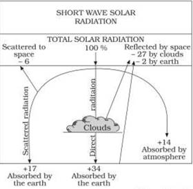
INCOMING SOLAR RADIATION
1. Figure 9.2 depicts the heat budget of the planet earth. The earth as a whole does Not accumulate or loose heat. It maintains its temperature.
2. This can happen only if the amount of heat received in the form of insolation equals the amount lost by the earth through terrestrial radiation.
3. Consider that the insolation received at the top of the atmosphere is 100 percent.
4. While passing through the atmosphere some amount of energy is reflected, scattered and absorbed.
5. Only the remaining part reaches the earth surface.
6. Roughly 35 units are reflected back to space even before reaching the earth’s surface.
7. Of these, 27 units are reflected back from the top of the clouds
8. Only 2 units from the snow and ice-covered areas of the earth.
9. The remaining 65 units are absorbed,
10. 14 units within the atmosphere and 51 units by the earth’s surface.
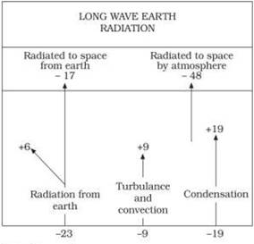
TERRESTRIAL RADIATION
1. The earth radiates back 51 units in the form of terrestrial radiation.
2. 17 units are radiated to space directly
3. the remaining 34 units are absorbed by the atmosphere
4.6 units absorbed directly by the atmosphere,
5.9 units through convection and turbulence
6. 19 units through latent heat of condensation
7.48 units absorbed by the atmosphere (14 units from insolation +34 units from terrestrial radiation) are also radiated back into space.
Thus, the total radiation returning from the earth and the atmosphere respectively is 17+48=65 units which balance the total of 65 units received from the sun. This is termed the heat budget or heat balance of the earth.
This explains, why the earth neither warms up nor cools down despite the huge transfer of heat that takes place.
What do you mean by ‘Albedo’?
The reflected amount of radiation is called the albedo of the earth.
Variation in the Net Heat Budget at the Earth’s Surface
As explained earlier, there are variations in the amount of radiation received at the earth’s surface. Some part of the earth has surplus radiation balance while the other part has deficit.
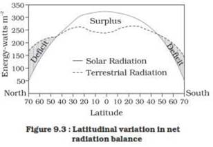
Figure 9.3 depicts the latitudinal variation in the net radiation balance of the earth the atmosphere system.
The figure shows that there is a surplus of net radiation balance between 40 degrees north and south and the regions near the poles have a deficit.
The surplus heat energy from the tropics is redistributed pole wards and as a result the tropics do not get progressively heated up due to the accumulation of excess heat or the high latitudes get permanently frozen due to excess deficit.
WHAT IS THE DIFFERENCE BETWEEN HEAT AND TEMPERATURE
Temperature
The interaction of insolation with the atmosphere and the earth’s surface creates heat which is measured in terms of temperature.
While heat represents the molecular movement of particles comprising a substance, the temperature is the measurement in degrees of how hot (or cold) a thing (or a place) is.
Factors Controlling Temperature Distribution
The temperature of air at any place is influenced by
(i) the latitude of the place;
(ii) the altitude of the place;
(iii) distance from the sea, the air mass circulation;
(IV) the presence of warm and cold ocean currents;
(v) local aspects.
1. The latitude: The temperature of a place depends on the insolation received. It has been explained earlier that the insolation varies according to the latitude hence the temperature also varies accordingly.
2. The altitude: The atmosphere is indirectly heated by terrestrial radiation from below. Therefore, the places near the sea-level record higher temperature than the places situated at higher elevations. In other words, the temperature generally decreases with increasing height. The rate of decrease of temperature with height is termed as the normal lapse rate. It is 6.5°C per 1,000 m.
Distance from the sea: Another factor that influences the temperature is the location of a place with respect to the sea. Compared to land, the sea gets heated slowly and loses heat slowly. Land heats up and cools down quickly. Therefore, the variation in temperature over the sea is less compared to land. The places situated near the sea come under the moderating influence of the sea and land breezes which moderate the temperature.
Air-mass: Like the land and sea breezes, the passage of air masses also affects the temperature. The places, which come under the influence of warm air-masses experience higher temperature and the places that come under the influence of cold air masses experience low temperature.
Ocean Currents
Similarly, the places located on the coast where the warm ocean currents flow record higher temperature than the places located on the coast where the cold currents flow.
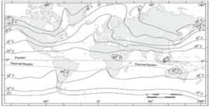
Isotherms are lines joining places having equal temperature.
Fig no. 9.4 (a) distribution of surface temperature in the month of January Figure 9.4 (a) and (b) show the distribution of surface air temperature in the month of January and July.
1. In general the effect of the latitude on temperature is well pronounced on the map,
2. the isotherms are generally parallel to the latitude.
3. The deviation from this general trend is more pronounced in January than in July, especially in the northern hemisphere.
4. In the northern hemisphere the land surface area is much larger than in the southern hemisphere.
5. Hence, the effects of land mass and the ocean currents are well pronounced.
In January the isotherms deviate to the north over the ocean and to the south over the continent. This can be seen on the North Atlantic Ocean.
INVERSION OF TEMPERATURE
Normally, temperature decreases with increase in elevation. It is called normal lapse rate. At times, the situations is reversed and the normal lapse rate is inverted. It is called Inversion of temperature. Inversion is usually of short duration but quite common nonetheless. A long winter night with clear skies and still air is ideal situation for inversion. The heat of the day is radiated off during the night, and by early morning hours, the earth is cooler than the air above.
CBSE Class 11 Revision Notes and Key Points
Solar Radiation, Heat Balance and Temperature class 11 Notes Geography. CBSE quick revision note for class-11 Mathematics, Physics, Chemistry, Biology, and other subject are very helpful to revise the whole syllabus during exam days. The revision notes covers all important formulas and concepts given in the chapter. Even if you wish to have an overview of a chapter, quick revision notes are here to do if for you. These notes will certainly save your time during stressful exam days.
- Physics
- Chemistry
- Mathematics
- Biology
- Accountancy
- Economics
- Business Studies
- Computer Science
- Informatics Practices
- Geography
To download Solar Radiation, Heat Balance and Temperature class 11 Notes, sample paper for class 11 Chemistry, Physics, Biology, History, Political Science, Economics, Geography, Computer Science, Home Science, Accountancy, Business Studies, and Home Science; do check myCBSEguide app or website. myCBSEguide provides sample papers with solution, test papers for chapter-wise practice, NCERT solutions, NCERT Exemplar solutions, quick revision notes for ready reference, CBSE guess papers and CBSE important question papers. Sample Paper all are made available through the best app for CBSE students and myCBSEguide website.
- India – Location class 11 Notes Geography
- Structure and Physiography class 11 Notes Geography
- Drainage System class 11 Notes Geography
- Climate Vegetations and Soil class 11 Notes Geography
- Natural Vegetation class 11 Notes Geography
- Soils class 11 Notes Geography
- Geography as a Discipline class 11 Notes Geography
- Interior of the Earth class 11 Notes Geography
- Distribution of Oceans and Continent class 11 Notes Geography
- Minerals and Rocks class 11 Notes Geography
- Geomorphic Processes class 11 Notes Geography
- Landforms and their Evolution class 11 Notes Geography
- Solar Radiation, Heat Balance and Temperature class 11 Notes Geography
- Atmospheric Circulation and Weather System class 11 Notes Geography
- Water in the Atmosphere class 11 Notes Geography
- World Climate and Climate Change class 11 Notes Geography
- Water oceans class 11 Notes Geography
- Movements of Ocean Water class 11 Notes Geography
- Life on the Earth class 11 Notes Geography
- Biodiversity and Conservation class 11 Notes Geography
- Natural Hazards and Disasters class 11 Notes Geography
- The Origin and Evolution of the Earth class 11 Notes Geography
- Climate class 11 Notes Geography
Test Generator
Create question paper PDF and online tests with your own name & logo in minutes.
Create Now
Learn8 App
Practice unlimited questions for Entrance tests & government job exams at ₹99 only
Install Now