CBSE Sample Papers Class 12 Geography 2025
Download Free Class 12 Geography Sample Paper 2025 with Solutions on myCBSEGuide App and also visit our myCBSEGuide Website. Prepare for your CBSE Class 12 Geography 2025 exams with the latest Geography sample papers, designed to align with the updated CBSE syllabus and marking scheme. These practice papers offer a mix of subjective and objective questions to help you strengthen your concepts and boost your exam performance. Access Class 12 Geography test papers, NCERT solutions, revision notes, and important question papers for comprehensive study. How can I download NCERT notes and solutions for free? The myCBSEguide app and website provide free downloadable resources, including CBSE board exam sample papers, to help students master key topics. Start practicing today and gain confidence with detailed solutions and expert-curated Geography exam papers to excel in your 2025 CBSE board exams.
Sample paper of Geography Class 12 – in PDF
The new CBSE marking scheme and blueprint for the Class 12 Geography 2024-25 session have been released for the 2025 board exams. Our website myCBSEguide provides free downloadable Geography sample papers for Class 12 CBSE on our app and website in PDF format. These sample papers, along with detailed solutions, are aligned with the updated CBSE exam pattern and marking scheme, helping students prepare efficiently. By practicing these sample papers, students can familiarize themselves The Class 12 Geography sample papers available on myCBSEguide are designed to help you practice the types of questions that may appear in your CBSE board exam. For teachers, the Examin8 App or Examin8 Website is a perfect tool to create customized test papers with your name and logo. This feature allows educators to design personalized assignments and exams, enhancing the learning experience for students.
Sample Papers of Class 12 Geography 2025 with solution
CBSE Sample Papers Class 12 Geography 2025
Download CBSE Class 12 Geography Sample Papers 2025 with Solutions for Free
myCBSEguide offers free downloadable CBSE Class 12 Geography sample papers for the year 2025, complete with detailed solutions in PDF format. These sample papers are available for download directly from the myCBSEguide app and website. These sample papers are based on the latest CBSE syllabus and NCERT textbooks, ensuring that students are well-prepared for the 2025 CBSE board exams. The sample papers Class 12 Geography align with the new exam blueprint and marking scheme for the year, giving students a clear idea of the exam pattern and question format.
Sample Questions Papers Class 12 Geography
CBSE Class 12
Geography (Code No. 029)
Practice Paper (2024-25)
Maximum Marks: 70
Time Allowed: : 3 hours
General Instructions:
Read the following instructions carefully and follow them:
- This question paper contains 30 questions. All questions are compulsory.
- Question paper is divided into five sections A, B, C, D and E.
- Section A Questions no. 1 to 17 are Multiple Choice type questions. Each question carries 1 mark.
- Section B Questions no. 18 and 19 are Source-based questions. Each question carries 3 marks.
- Section C Questions no. 20 to 23 are Short Answer type questions. Each question carries 3 marks. Answer to these questions shall be written in 80 to 100 words.
- Section D Questions no. 24 to 28 are Long Answer type questions. Each question carries 5 marks. Answer to these questions shall be written in 120 to 150 words.
- Section E Questions no. 29 and 30 are Map-based questions. Each question carries 5 marks.
- There is no overall choice given in the question paper. However, an internal choice has been provided in a few questions in all sections other than Section A.
Section A
-
- Assertion (A): Some people do not have the capability and freedom to make even basic choices.
Reason (R): They have very limited choices and do not have the means to a decent life.a) Both A and R are true and R is the correct explanation of A.b) Both A and R are true but R is not the correct explanation of A.c) A is true but R is false.d) A is false but R is true. - Match the following correctly
Europeans Crops introduced in colonies (a) French (i) Tea garden in India (b) Spanish and Americans (ii) Sugarcane in Indonesia (c) British (iii) Coffee and cocoa in West Africa (d) Dutch (iv) Coconut and Sugarcane in Philipines a) (a) – (ii), (b) – (iii), (c) – (i), (d) – (iv)b) (a) – (iii), (b) – (iv), (c) – (i), (d) – (ii)c) (a) – (iv), (b) – (i), (c) – (iii), (d) – (ii)d) (a) – (iv), (b) – (iii), (c) – (ii), (d) – (i) - The Big Inch Pipe Line is located in which of these countries?
a) Canadab) Russiac) USAd) UK
- Consider the following statements and choose the correct option for the same:
- More concentration of population resulted in compact or clustered rural settlements.
- Fertile plain provides a more agricultural output which attracts more population to live and engage in agriculture.
a) Only i is correctb) Only ii is correctc) Both the statements are incorrectd) Both statements are correct and statement ii correctly explains the statement i - When was the human development index created?
a) 1955b) 1985c) 1980d) 1990
- Kakrapara nuclear power project is located in which one of the following State?
a) Tamil Nadub) Maharashtrac) Gujaratd)Karnataka
- Which state in India produces the largest quantity of coal?
a) Biharb) West Bengalc) Odishad) Tamil Nadu
- Temporary or a permanent decline in productive capacity of the land is known as:
a) Barren landb) Land degradationc) Desalination of landd) Marshy land
- Reindeer is a pack animal in:
a) Australiab) Africac) Siberiad) South America
- Consider the following statements and choose the correct option for the same:
- Empowerment comes from increasing freedom and capability.
- Good governance and people-oriented policies are required to empower people.
a) Only i is correctb) Both the statements are incorrectc) Only ii is correctd) Both statements are correct and statement ii correctly explains the statement i - Arrange the following countries in sequential order according to the life expectancy rate.
Choose the correct option.- Switzerland
- Hong Kong
- Macao
- Japan
a) ii, iv, iii, ib) ii, iv, iii, ic) ii, iii, i, ivd) i, iii, iv, ii - Who was the father of modern human geography?
a) Campbellb) Humboldtc) Ritterd) Ratzel
- Where is Silicon Valley located?
a) San Franciscob) Bostonc) Montreald) New York
- Which one of the following states has the highest percentage of urban population?
a) Gujaratb) Maharashtrac) Keralad) Goa
- Assertion (A): Some people do not have the capability and freedom to make even basic choices.
- Question No. 15 to 17 are based on the given text. Read the text carefully and answer the questions:Study the given graph carefully and answer the following questions:
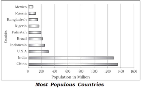
- The 10 most populous countries of the world contribute about ________ of the world’s population.
a) 55%b) 30%c) 60%d) 50%
- Which of the following refers to population distribution?
a) The change in number of inhabitants of a territory during a specific period of time.b) The way people are spaced over the earth’s surface.c) The change of population expressed in percentage.d) The ratio between the numbers of people to the size of land.
- 90 percent of the world population lives in about how much percentage of its land area?
a) 25%b) 20%c) 50%
d) 10%
Download myCBSEguide App for Comprehensive Exam Preparation
To practice more questions and prepare effectively for your exams, download the myCBSEguide app today. It offers complete study material for CBSE, NCERT, JEE (Main), NEET-UG, and NDA exams. Whether you’re aiming for high scores in your CBSE board exams or preparing for competitive exams like JEE, NEET, or NDA, myCBSEguide provides all the resources you need.
For teachers, the Examin8.com app allows you to create custom exam papers with your own name and logo, making it easier to design personalized assessments for students.
Download the myCBSEguide app and Examin8 app now to get access to exam papers, study materials, mock tests, and much more, all designed to help you ace your exams and achieve your goals.
- Section B
- All economic activities namely primary, secondary, tertiary and quaternary, revolve around obtaining and utilising resources necessary for survival.Secondary activities add value to natural resources by transforming raw materials into valuable products. Cotton in the boll has limited use but after it is transformed into yarn, becomes more valuable and can be used for making clothes. Iron ore, cannot be used; directly from the mines, but after being converted into steel it gets its value and can be used for making many valuable machines, tools, etc. The same is true of most of the materials from the farm, forest, mine and the sea. Secondary activities, therefore, are concerned with manufacturing, processing and construction (infrastructure) industries.
- What are secondary activities?
- What is the importance of secondary activities in the world?
- Which processes help secondary activities?
- Study the map given below carefully and answer the following questions.
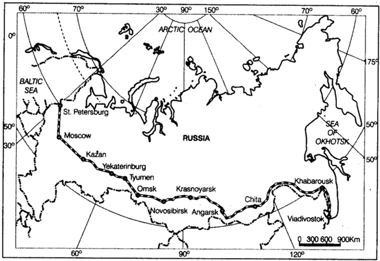
- Identify and name the railway line shown on the map. (1)
- Name the continents linked by this rail route. (1)
- Explain how this railway line is helpful for the promotion of trade in this region? (1)
-
Section C
- Discuss how increasing demand for water is a challenge to India. OR
Analyse the economic and social values of rain water harvesting. - Study the following chart and answer:
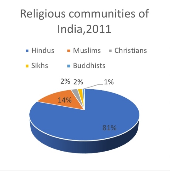 Source: Census of India, 2011
- Which are the smallest religious groups in India?
- In which area Christian population is mostly concentrated?
- Why it is important to study the religious composition of any country?
- How is the favourable balance of trade an indicator of economic development of a country?
- Explain the main features of periodic markets in rural areas of the world.
- Section D
- Mediterranean agriculture is highly specialized commercial agriculture in the world. Support the statement.
- Oceanic routes play an important role in the transport sector of India’s economy. Examine the statement.ORIn India Satellite Communication has became vital for the country. Examine the statement.
- Explain with examples the development of International Trade.ORWhat is the role of the World Trade Organisation as an international organisation? Why has the World Trade Organisation been criticised by some countries?
- Critically analyse the Vast Underemployment as a problem of Indian Agriculture.ORLand use in a region to a large extent is influenced by nature economic activities carried out in that region. Support the statement by giving three examples from India.
- Analyse any five objectives of Drought Prone Area Development Programme.ORSuppose you have given the power to modify the planning process. How would you use this power wisely and what would be your plan? Explain with reason.
- Section E
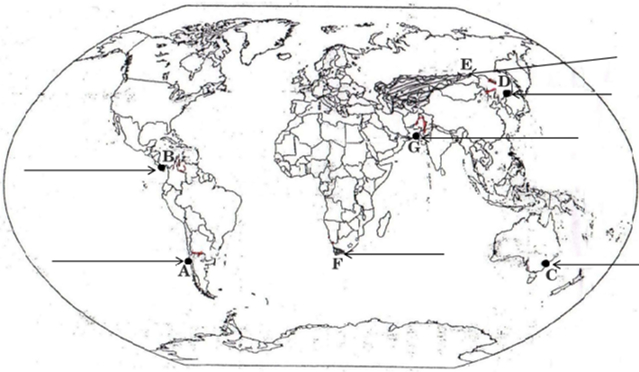
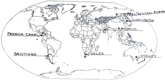
- On the given political outline map of the World seven geographical features have been marked as A, B, C, D, E, F and G. Identify any five with the help of the following information and write their correct names on the lines drawn near them:
- An international airport in South America
- A canal linking Atlantic Ocean with Pacific Ocean
- A major seaport in Australia
- A terminal station of Trans-Siberian Railway
- A major area of commercial livestock rearing
- An area of extensive commercial grain farming
- A major seaport in Asia
- Locate and label any five of the following geographical features on the Political Outline map of India with appropriate symbols:
- Iron ore mines of Karnataka
- Oil Refinery located in Gujarat
- The coal mines of the largest coalfield in Jharkhand
- The state with highest population density
- An international airport in Telangana
- Bauxite mines located in Madhya Pradesh
- The state leading in the production of Tea
Download the myCBSEGuide for Comprehensive Exam Preparation
To boost your exam preparation and practice more questions, download the myCBSEguide app or visit the myCBSEGuide Website. It offers complete study material for CBSE, NCERT, JEE (Main), NEET-UG, and NDA exams. Whether you’re studying for the CBSE board exams or preparing for competitive exams like JEE, NEET, or NDA, the myCBSEguide app provides the resources you need to succeed.
For teachers, the Examin8 Website allows you to easily create custom exam papers with your own name and logo, offering a personalized assessment experience for your students.
Download the myCBSEguide app and Examin8 app today to access a wide range of exam papers, mock tests, study notes, and much more to enhance your exam preparation.
Sample Question Paper Class 12 Geography with their Solutions
Solution
Section A
- (c) A is true but R is false.Explanation: People do not have the capability and freedom to make even basic choices. This may be due to their inability to acquire knowledge, their material poverty, social discrimination, the inefficiency of institutions, and other reasons. This prevents them from leading healthy lives, being able to get educated, or having the means to live a decent life.The assertion is correct but the reason is incorrect.
- (b) (a) – (iii), (b) – (iv), (c) – (i), (d) – (ii)
Explanation:(a) – (iii), (b) – (iv), (c) – (i), (d) – (ii) - (c) USA
Explanation:USA - (d) Both statements are correct and statement ii correctly explains the statement i
Explanation:Both statements are correct and statement ii correctly explains the statement i - (d) 1990
Explanation:1990 - (c) Gujarat
Explanation:Gujarat - (c) Odisha
Explanation:Odisha is the third-largest producer of coal in India. Odisha is the largest coal producing State with a share of about 21.2% . Talcher is the major coal-producing region in Odisha. Ranpur and Jharsuguda are other coal-producing areas in the state. - (b) Land degradation
Explanation:Soil erosion, waterlogging, salinisation and alkalinisation of land lead to land degradation. - (c) Siberia
Explanation:Reindeers are used in Siberia to draw sledges over snow-covered ground. - (d) Both statements are correct and statement ii correctly explains the statement i
Explanation:Both statements are correct and statement ii correctly explains the statement i - (b) ii, iv, iii, i
Explanation:ii, iv, iii, i - (d) Ratzel
Explanation:Ratzel - (a) San Francisco
Explanation:San Francisco - (d) Goa
Explanation:Goa has the highest percentage of urban population among Indian states. Its urban population is significantly higher compared to other states in India, largely due to its relatively small size and high level of urbanization. - (c) 60%
Explanation:60% - (b) The way people are spaced over the earth’s surface.
Explanation:The way people are spaced over the earth’s surface. - (d) 10%
Explanation:10%
Download the myCBSEguide App for Comprehensive Exam Preparation
Prepare effectively and practice more questions by downloading the myCBSEguide app. It offers complete study material for CBSE, NCERT, JEE (Main), NEET-UG, and NDA exams. If you are preparing for the CBSE board exams or preparing for competitive exams like JEE, NEET, or NDA, the myCBSEguide app provides all the essential resources to help you succeed.
For teachers, the Examin8.com app enables you to create customized exam papers with your own name and logo, making it easy to personalize assessments for your students.
Download CBSE Class 12 Geography Sample Papers 2025 for Effective Exam Preparation
Download the myCBSEguide app and Examin8 app today to access exam papers, mock tests, study notes, and much more to boost your exam preparation and performance.
Section B
- Activities which add value to natural resources and transform them into useful products is called secondary activities.Manufacturing and Industry sector known as secondary sector, sometimes as production sector, includes all branches of human activities that transform raw materials into products or goods.
- The importance of secondary activities is that these activities add value to the natural resources by the transformation of raw materials into useful and valuable products.
- Secondary activities change the form and value of raw material by the following process:
- manufacturing
- processing
- construction(infrastructure)
-
-
- Trans-Siberian railway line has been shown on the map.
- It connects Asia and Europe.
- This railway line runs across the Ural mountains and connects agro centres like Chita and Irkutsk. It also acts as a linkage between different manufacturing centres.
- Section C
- Increasing demand for water is a challenge to India:
- India has a large population with limited water resources.
- Rising demand for the increasing population.
- More water is required for irrigation to increase agriculture production as rainfall is highly variable.
- Rapid industrial growth is the increasing demand for water.
- Urbanisation and modern lifestyle have increased demand.
- The share of agricultural sector in total water utilisation is much higher than in other sectors.
OR
The economic and social values of rain-water harvesting are given below:
- Rain-water harvesting technique is environment-friendly as well as cost-effective for people.
- This technique guides to store rain-water into bore wells, pits, etc for future use and in times of scarcity of water.
- It creates sensitivity and awareness among people about the benefits of conservation and reuse of water.
- This technique helps to reduce floods like situation and also save life and property
- It helps to reduce conflict among states and communities.
- The smallest religious groups in India are Sikhs and Buddhists.
- The Christian population is distributed mostly in rural areas of the country. The main concentration is observed along the Western coast around Goa, Kerala and in the north-eastern region.
- Religion is one of the most dominant forces affecting the cultural and political life of the majority of Indians. It also permeates into almost all the aspects of people’s family and community lives, it is important to study the religious composition.
- If the value of export is more than the value of import than the country has a positive or favourable balance of trade. It means the country is earning money by selling its goods to another country. Favourable balance of trade is the indicator of economic development of the country.
- These markets are organized in rural areas at different periods where there are no regular markets
- These markets may be weekly or biweekly.
- These markets are held on different dates at different places.
- These markets cater to the demand of the local population.
- Shopkeepers remain always busy
- Section D
- Mediterranean Agriculture:
- It is practised in the countries on either side of the Mediterranean Sea in Europe and in North Africa from Tunisia to the Atlantic coast southern California central Chile southwestern parts of South Africa and south and southwestern parts of Australia.
- This region is an important supplier of citrus fruits.
- Viticulture or grape cultivation is a speciality of the Mediterranean region.
- Best quality wines in the world with distinctive flavours are produced from high-quality grapes in various countries of this region.
- The inferior grapes are dried into raisins and currants. This region also produces olives and figs.
- The advantage of Mediterranean agriculture is that more valuable crops such as fruits and vegetables are grown in winters when there is great demand in European and North American markets.
- Approximately 95 per cent of India’s foreign trade by volume and 70 per cent by value moves through ocean routes.
- Apart from international trade, these are also used for the purpose of transportation between the islands and the rest of the country.
- Our country earns a lot of money from major commercial ports like Mumbai and Kolkata.
- Heavy machinery required for industrial and infrastructure development is transported via oceanic routes.
- The oceanic route facilitates national export and import, resulting in an increase in national GDP.
- OR
- After the U.S.A. and former U.S.S.R. pioneered space research communication through satellites emerged as a new area in communication technology since the 1970s.
- Satellite communication is beneficial in telecommunication. The internet has completely transformed our country’s telecommunications system.
- It has improved our country’s weather forecasting system. India’s weather forecasting system is now more accurate and can detect natural disasters such as cyclones much earlier.
- Furthermore, it aids India in maintaining border surveillance.
- It also aids the country in the preservation of its natural resources. It aids in the detection of new mining ventures.
- Nations trade internationally when there are not the resources or capacity to satisfy domestic needs and wants domestically. By developing and exploiting their domestic resources, countries can produce a surplus. They may use this surplus to buy goods they need from abroad, i.e. through international trade.Development of International Trade:
- In ancient times, transporting goods over long distances was risky, hence trade was restricted to local markets.
- Earlier people spent most of their resources on the basis of necessities-food and clothes.
- Only the rich people bought jewellery, costly dresses and this resulted in the trade of luxury items.
- Fifteenth-century onwards, the European colonization began along with the trade of exotic commodities (a new form of trade emerged which was called the slave trade)
- After the Industrial Revolution, the industrialised nation imported primary products as raw material and exported the value-added finished products to the non-industrialized nations.
- In the latter half of the nineteenth century, the industrial nations became each other’s principal customers.
- Post World War II, organizations like GATT (WTO) was formed to reduce tariffs to regulate International Trade.
OR
In1948, to liberalize the world from high customs tariffs and various other types of restrictions, General Agreement for Tariffs and Trade (GATT) was formed by some countries. In 1994, it was decided by the member countries to set up a permanent institution for looking after the promotion of free and fair trade amongst nation and the GATT was transformed into the World Trade Organisation (WTO) from 1st January 1995. WTO is the only international organisation dealing with the global rules of trade between nations.
The functions of WTO are as follows:
- It sets the rules for the global trading system.
- It promotes free and fair trade amongst different countries of the world.
- WTO also covers trade in services, such as telecommunication and banking, and other issues such as intellectual rights.
World Trade Organisation has always been criticised by those who are worried about the effects of free trade and economic globalisation. The critique of WTO is based on an argument that free trade is not beneficial to ordinary people as it is widening the gulf between rich and poor by making rich countries more richer. This is because influential nations try to satisfy their commercial interests through WTO. In addition, these countries have not fully opened their markets to developing countries. Critics also argue that important issues like health, workers’ rights, child labour and environment have been ignored by WTO.
- Underemployment in Indian agriculture is a significant issue. This problem arises due to the seasonal nature of farming, with intense labor demand during planting and harvest seasons, but limited work in off-seasons. Small and fragmented landholdings restrict efficient farming practices and mechanization, leading to excessive labor use. Moreover, a large rural population depends on agriculture, which cannot provide full employment due to low productivity and limited land resources. There is a massive underemployment in the agricultural sector in India, particularly in the unirrigated tracts. In these areas, there is a seasonal unemployment ranging from 4 to 8 months. Even in the cropping season, work is not available throughout as agricultural operations are not labour intensive. Hence, the people engaged in agriculture do not have the opportunity to work round the year.
Consequences of underemployment include low income levels, perpetuating poverty in rural areas, and prompting rural-urban migration, which strains urban infrastructure. Additionally, low agricultural productivity hinders economic growth and exacerbates socio-economic inequalities between rural and urban areas.ORIncreasing population pressure on land is one of the major reasons which is responsible for the decline in land under pasture and grazing area. There are three types of economic changes that affected the land use in India which are as follows:
-
- Discuss how increasing demand for water is a challenge to India. OR
- As the population increases the size of the economy also increases. A high population pressurizes land resources and forces people to utilise every piece of land. Thus, marginal lands and barren wastelands would be used to support the population.
- When the composition of an economy changes it also changes the land uses because different sectors use the land for different purposes, e.g. when agricultural area decreases the area under other categories like the area under non-agriculture use increases.
- With the compositional change in economy and change in land use, the area under agriculture declines, but it does not reduce the population pressure on agriculture land.
- The objectives of the Drought Prone Area Development Programme (DPAP) are as follows:
- Enhancing Agricultural Productivity: DPAP aims to improve agricultural practices and productivity in drought-prone areas. It focuses on introducing water-saving techniques, crop diversification, soil conservation measures, and efficient irrigation methods to mitigate the impact of droughts and enhance agricultural output.
- Water Resource Management: The program aims to develop and manage water resources effectively in drought-prone regions. It includes activities like construction and restoration of water storage structures, rainwater harvesting, watershed management, and promoting efficient water usage to ensure sustainable water availability.
- Soil Conservation and Land Reclamation: DPAP emphasizes soil conservation measures to prevent soil erosion and degradation. It promotes techniques such as contour bunding, terracing, afforestation, and reclamation of degraded lands to improve soil fertility and prevent land degradation in drought-prone areas.
- Livelihood Diversification: The program focuses on diversifying livelihood options for the communities residing in drought-prone areas. It encourages the development of alternative income sources such as livestock rearing, fisheries, horticulture, agro-forestry, and non-farm activities to reduce the dependency on rain-fed agriculture and enhance the resilience of the local communities.
- Capacity Building and Institutional Strengthening: DPAP aims to strengthen the institutional capacity at the grassroots level by providing training and capacity-building programs to farmers, community-based organizations, and local administration. It promotes the formation of self-help groups, farmer cooperatives, and user groups to enhance community participation and decision-making processes for sustainable development.
These objectives collectively aim to alleviate the adverse impacts of drought and improve the socio-economic conditions of the communities residing in drought-prone areas.
OR
If I had some power to modify the present planning process, I would have broadened the planning process by adding some important terms such as:
- Equity: It means making equal access to opportunities available to everybody. The opportunities available to people must be equal irrespective of their gender, race, income and caste.
- Sustainability: It refers to continuity in the availability of opportunities. This means that each generation must have the same opportunities, therefore we must use our environmental, financial and human resources in such a way that our future generations are not deprived of these opportunities.
- Empowerment: It refers to have the power to make choices. Such power comes from increasing freedom and capability. Good governance and people-oriented policies are required to empower people. The empowerment of social and economically disadvantaged groups are of special importance.
Section E
-
- Santiago
- Panama Canal
- Sydney
- Vladivostok
- Steppes/Central Euras
- Velds
- Karachi
Download myCBSEguide app for CBSE sample papers, solutions. For more visit our Website myCBSEGuide
Sample Papers for Class 12 – 2025
- Physics
- Chemistry
- Mathematics
- Biology
- English Core
- Business Studies
- Economics
- Accountancy
- Computer Science
- Informatics Practices
- Hindi Core
- Hindi Elective
- History
- Political Science
- Geography
- Home Science
- Physical Education
- Other Subjects
Download CBSE Class 12 Sample Papers 2025 for Geography, Physics, Chemistry, Biology & More
To download CBSE Sample Papers for Class 12 Geography 2025 and other subjects like Physics, Chemistry, Biology, History, Political Science, Economics, Computer Science, Home Science, Accountancy, and Business Studies, visit the myCBSEguide app or website. myCBSEguide offers a comprehensive collection of sample papers with solutions, test papers for chapter-wise practice, NCERT solutions, NCERT Exemplar solutions, quick revision notes, CBSE guess papers, and important question papers.
Accessing these resources through the best app for CBSE students and myCBSEguide website will help you prepare thoroughly for your exams. Whether you’re looking for subject-wise practice or last-minute revisions, myCBSEguide provides everything you need to succeed in your Class 12 board exams.
Test Generator
Create question paper PDF and online tests with your own name & logo in minutes.
Create Now
Learn8 App
Practice unlimited questions for Entrance tests & government job exams at ₹99 only
Install Now