Shaping of the Earth’s Surface – NCERT Solutions Class 9 Understanding Society (Social Science) includes all the questions with solutions given in the NCERT Class 9 Social Science Book Understanding Society textbook.
NCERT Solutions Class 9
English Kaveri Hindi Ganga Sanskrit Sharada Maths Ganita Manjari Science Exploration Social Understanding SocietyShaping of the Earth’s Surface – NCERT Solutions
Q.1: What shapes the Earth’s surface?
Solution: Earth’s surface changes because of internal forces that build it up and external forces that wear it down. Internal forces (like plate tectonics and volcanoes) push land up. External forces (like wind, water, and ice) break down and move the rock.
Q.2: What is plate tectonics? What are the effects of plate movement?
Solution: Plate tectonics is the scientific theory that Earth’s rocky outer shell is broken into moving pieces called tectonic plates. These plates float on a hot, semi-fluid layer of rock beneath them. The heat from Earth’s core drives them around like boiling water in a pot.
Plate movements cause major changes on Earth’s surface:
Earthquakes: Plates grind and get stuck. When they suddenly break free, they release massive energy.
Volcanoes: When one plate sinks under another, it melts into magma. The magma rises to the surface.
Mountains: When plates crash into each other, the ground buckles upward to form mountain ranges like the Himalayas.
Trenches: When one heavy plate slides under a lighter plate, it creates deep ocean trenches.
Q.3: How are landforms formed and how are they classified?
Solution: Landforms are features on the Earth’s surface that make up the terrain, such as mountains, valleys, plains or plateaus. Landforms are formed by both endogenic and exogenic forces.
Endogenic forces: Sudden forces like earthquakes, volcanoes, and landslides.
Exogenic forces: Erosional and depositional landforms formed because of agents like water, wind, sea waves and glaciers.
Q.4: How are humans and other living beings connected to these landforms?
Solution: Humans and other living beings are deeply connected to landforms like plains, mountains, and valleys. These physical shapes control our homes, food, and daily activities. Every creature adapts to its land to survive.
Q.5: How do disasters associated with different landforms impact human lives?
Solution: Disasters linked to landforms cause major hardships like property damage, illness, and loss of life. For example, coastal disasters lead to massive flooding. Mountain disasters bury towns with mud and rock. Flat plains face river floods that wash away crops. Each specific area changes how people survive.
Q.6: What are the sources of energy that are required to cause movements associated with the internal forces of the Earth?
Solution: Earth’s internal forces are driven by two main energy sources: primordial heat and radioactive decay, both working alongside gravity.
Here is how they work:
Primordial Heat: This is the leftover heat from when Earth first formed 4.5 billion years ago. Think of it like a freshly baked pie cooling on a windowsill. The inside is still very hot!
Radioactive Decay: Deep inside Earth, unstable atoms (like uranium and potassium) break apart. This process shoots out energy, creating new heat.
Gravity: Gravity pulls heavier materials toward the planet’s center. This movement creates friction and more heat. It also pushes up lighter, warmer rock while sinking heavy, cold rock.
Q.7: Relate various physiographic divisions you have studied in the earlier grades with various endogenic forces responsible for their origin.
Solution: Endogenic forces are internal forces that shape Earth’s surface. They are responsible for the formation of major physiographic divisions. Fold mountains, such as the Himalayas, were formed by the collision of tectonic plates. Plateaus, like the Deccan Plateau, developed through volcanic activity. Rift valleys were created by faulting due to tectonic movements. Thus, plate movement, folding, faulting, and volcanism have played a key role in forming different landforms.
Q.8: Why and where do earthquakes occur frequently? Is it possible to predict earthquakes?
Solution: Earthquakes most often happen along plate boundaries where two tectonic plates meet. The plates’ motions-whether they converge, diverge, or slip past one another-build up stress in the crust. A sudden release of that stress produces ground shaking, which we observe as an earthquake. The Pacific “Ring of Fire” sees the highest frequency of earthquakes because numerous plate boundaries lie there. In India, regions close to the Himalayas are particularly susceptible due to the ongoing collision between the Indian and Eurasian plates.
While scientists can map zones likely to experience earthquakes and assess probabilities from historical patterns and plate dynamics, they cannot predict the precise timing, location, or magnitude of a quake. Therefore, residents in earthquake-prone areas should be prepared and follow recommended safety practices.
Q.9: “Plate movements are responsible for the distribution of earthquakes and volcanoes.” Explain.
Solution: Tectonic plates are constantly moving slowly. Their movement creates stress and friction at plate boundaries, which leads to earthquakes and volcanic activities. The distribution of earthquakes and volcanoes is mainly related to different types of plate boundaries:
Convergent boundaries: When two plates collide, one plate may sink beneath the other (subduction). This process produces magma, causing volcanic eruptions and strong earthquakes. Example: Japan and the Andes.
Divergent boundaries: When plates move apart, magma rises and forms new crust, causing volcanic activity and earthquakes. Example: Mid-Atlantic Ridge.
Transform boundaries: When plates slide past each other, friction causes frequent earthquakes. Example: San Andreas Fault.
The Pacific Ring of Fire shows this relationship clearly, as it is a region with many active volcanoes and frequent earthquakes due to the movement of tectonic plates.
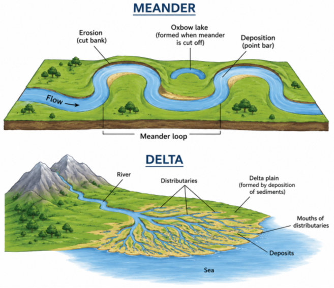
Q.10: Draw and label a diagram of a meander and a delta.
Solution:
Q.11: How are deforestation and erosion associated with each other? Explain.
Solution: Deforestation and soil erosion are closely linked. Deforestation removes trees. Trees act as nature’s anchors and shields. When trees are cut down, the soil loses its protection. This makes the land weak and vulnerable.
Deforestation causes soil erosion in these direct ways:
- Loss of Roots: Tree roots act like a net. They hold soil together tightly. Without roots, the soil turns loose.
- No Leaf Shield: Tree leaves block rain and wind. Without trees, heavy rain hits the bare ground. This rain acts like a hammer. It breaks the loose soil apart.
- Washing Away: The loose, broken soil is easily washed away by heavy water flow. This is called water erosion.
- Blowing Away: Strong winds can blow dry, unprotected soil away. This is called wind erosion.
- Erosion removes the top, nutrient-rich layer of soil. Without this good dirt, new plants cannot grow. This causes the land to dry up. Over time, it can lead to deserts.
Q.12: Develop a plan to protect the land in your local area from erosion.
Solution: Protect land from erosion in Noida by planting native grass to anchor loose soil, covering bare patches with mulch, and directing roof water away from foundations. These steps stop rain and wind from blowing or washing away your valuable topsoil.
Q.13: Which disasters do you think you might experience in your region? Discuss a mitigation plan in your classroom.
Solution: Based on the user’s location in the National Capital Region (NCR) of India, you are highly likely to experience severe heatwaves, heavy monsoon flooding, and poor air quality (smog). Earthquakes are also a serious threat since the region falls into high-risk Seismic Zones IV and V.
Here is a practical disaster mitigation plan that students can discuss and implement in the classroom to stay safe:
- Hazard Identification
Create a map of the classroom. Identify dangerous areas like large windows, heavy unsecured bookshelves, and blocked exits.
- The “Drop, Cover, and Hold On” Drill (for Earthquakes)
Drop to the floor on your hands and knees.
Cover your head and neck with your arms. Take cover under a sturdy desk or table.
Hold On to your shelter until the shaking stops.
Note: If you are outside during an earthquake, move to a clear, open area far from buildings, trees, and power lines.
- Evacuation Plan
Map out the fastest, safest routes to leave the building.
Assign a student “buddy” to help anyone who might need extra assistance, such as students with mobility issues.
Establish a designated “Assembly Point” in a safe, open space away from the school building.
- Classroom Emergency Kit
Gather and store these essential supplies in the classroom:
First aid kit (bandages, antiseptic, and gauze)
Clean bottled water and non-perishable snacks
A portable battery-operated radio and a loud whistle
Flashlights with extra batteries
- Clear Communication
Establish a clear communication system with parents and local emergency services. Create a “phone tree” or text group so families can be quickly notified if the school dismisses classes early due to heavy smog, heatwaves, or flooding.
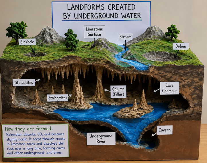
Q.14: Prepare a model of landforms created by underground water.
Solution:
Q.15: What precautionary measures will you take if you are staying in an earthquake-prone region?
Solution: Staying in an earthquake-prone region requires a mix of advance preparation and safe reflexes. Anchor heavy furniture to the walls, and know your safest spots inside. When the ground shakes, immediately drop, cover, and hold on. After the shaking stops, check for hazards and prepare for aftershocks.
Q.16: Prepare a map showing landform-associated disasters that happened in the current calendar year.
Solution: In 2026, several major landform-associated disasters occurred worldwide. On 24 June 2026, two powerful earthquakes (7.2 and 7.5 magnitude) struck Venezuela, causing heavy loss of life and property due to movement along a plate boundary. In April, a 7.7 magnitude earthquake off the coast of Japan triggered a tsunami warning. In May, the Mayon Volcano in the Philippines erupted, releasing a large ash cloud. In India, the Southwest Monsoon brought heavy rainfall, increasing the risk of floods and landslides in many regions.
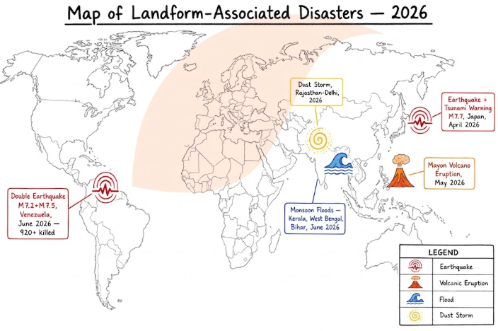
These disasters show that natural hazards mainly occur along plate boundaries, mountainous regions, and flood-prone areas, highlighting the close link between landforms and natural disasters.
Q.17: Create a poster showing landforms that are considered to be sacred or important in your region, and add the folk stories associated with them.
Solution: India has many sacred landforms connected with religion and folklore.
The Himalayas are known as the abode of the gods. Mount Kailash is believed to be the home of Lord Shiva, and the Char Dham shrines are located here.
River Ganga is worshipped as Goddess Ganga. According to legend, King Bhagirath brought the river to Earth, and Lord Shiva controlled its powerful flow.
Govardhan Hill (Uttar Pradesh) is where Lord Krishna is believed to have lifted the hill to protect the people of Vrindavan from heavy rains.
Tirumala Hills (Andhra Pradesh) are home to the famous Tirupati Balaji Temple and are believed to be the residence of Lord Vishnu.
Pushkar Lake (Rajasthan) is associated with Lord Brahma and is considered a holy place where pilgrims take a sacred dip during Kartik Purnima.
Q.18: Document a case of a disaster that hit your region in the past, highlighting its effects on various human activities.
Solution: Case Study: Chamoli Glacier Disaster, Uttarakhand (7 February 2021)
A large glacier collapsed in the Nanda Devi region, triggering a flash flood in the Rishiganga and Dhauliganga rivers.
Effects:
Over 200 people were killed or went missing.
Two major hydroelectric projects were severely damaged.
Roads and bridges were destroyed, disrupting transport.
Farmland was buried under debris, affecting agriculture.
Many local workers and businesses lost their livelihoods.
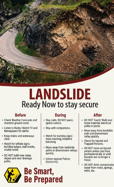
Q.19: Translate the given poster on landslide into your native language and display it in your home.
Solution:
भूमि खिंचाव – भूकंप से सावधान
पहले:
मिट्टी को पकड़े रखने वाले अधिक से अधिक पेड़ लगाएँ।
रेडियो, टीवी और अख़बार पर दी जाने वाली सभी सूचनाओं को ध्यान से सुनें।
नालियों को साफ़ रखें तथा चट्टानों की दरारों को बंद करें।
इमारतों की नींव में दरारें तथा गंदे नदी के पानी जैसे संकेतों पर ध्यान दें।
ढलानों और नालों के पास निर्माण न करें।
दौरान:
शांत रहें और अफ़वाहों पर ध्यान न दें।
अपने साथियों के साथ रहें।
भूमि खिंचाव वाले क्षेत्र/रास्ते से तुरंत दूर हो जाएँ।
निकट के तहसीलदार को इसकी सूचना दें।
बाद में:
बिजली के तारों और गिरी हुई सामग्री को न छुएँ।
भूमि खिंचाव वाले रास्तों तथा बाढ़ की घाटी से दूर रहें।
घायल व्यक्तियों की सहायता करें।
नदियों, झरनों और कुओं का पानी न पिएँ।
Q.20: Divide the class into three groups. Each group will work on one project (water, wind, and glacier). The project should highlight the causes, impact on human life and the environment, and mitigation measures.
Solution:
Group 1 – Water (Rivers, Rain, Floods)
Causes: Heavy rainfall, deforestation, glacier melting, silting of rivers.
Impact: Floods cause loss of life, crop damage, soil erosion, and damage to roads and houses. Rivers also provide fertile soil and irrigation.
Mitigation: Afforestation, embankments, dams, flood warning systems, and avoiding construction in flood-prone areas.
Group 2 – Wind (Dust Storms, Desert Erosion)
Causes: Strong winds, drought, deforestation, and climate change.
Impact: Soil erosion, crop damage, poor visibility, respiratory problems, and desertification. Wind also deposits fertile soil and provides renewable energy.
Mitigation: Plant shelterbelts, restore vegetation, use windbreaks, and adopt sustainable farming.
Group 3 – Glaciers (Glacial Floods, Avalanches)
Causes: Global warming, heavy snowfall, earthquakes, and human activities.
Impact: Glacial floods and avalanches damage villages, roads, and hydropower projects, while glacier melt threatens water supplies.
Mitigation: Early warning systems, restricted construction, afforestation, avalanche safety measures, and climate action.
Class 9 Social Science (New book) NCERT Solutions
- Understanding Social Science
- Shaping of the Earth’s Surface
- Atmosphere and Climate
- Early Humans and Beginning of Civilisation
- State and Society up to 1000 CE
- Democracy
- Elections
- Building Blocks in Economics: The Problem of Choice
- The Price Puzzle: What Drives the Market Edit

Test Generator
Create question paper PDF and online tests with your own name & logo in minutes.
Create Now
Learn8 App
Practice unlimited questions for Entrance tests & government job exams at ₹99 only
Install Now