
Ask questions which are clear, concise and easy to understand.
Ask QuestionPosted by Anushka Kumari 5 years, 4 months ago
- 1 answers
Posted by Jatin Sharma 5 years, 4 months ago
- 1 answers
Yogita Ingle 5 years, 4 months ago
Insolation : The energy received by the earth in the form of waves of short wave-lengths is known as incoming radiation or in short insolation.
Factors that influence isolation :
1. The amount and the intensity of insolation vary during in a day, in a season and in a year. The major factors that cause these variations in insolation are rotation of the earth on its axis, the angle of inclination of sun's rays and the length of the day.
2. Other modifying factors are transparency of the atmosphere and the configuration of landmass in terms of its aspects.
Posted by Sumit Kumar 5 years, 4 months ago
- 1 answers
Gaurav Seth 5 years, 4 months ago
The earthquake waves cause vibration in the body of the rocks through which they pass. P-waves vibrate parallel to the direction of the wave. This exerts pressure on the material in the direction of the propagation. As a result, it creates density differences in the material leading to stretching and squeezing of the material. Other three waves vibrate perpendicular to the direction of propagation. The direction of vibrations of S-waves is perpendicular to the wave direction in the vertical plane. Hence, they create troughs and crests in the material through which they pass. Surface waves are considered to be the most damaging waves.
Posted by Shivangi Yadav 5 years, 4 months ago
- 0 answers
Posted by Sumit Kumar 5 years, 4 months ago
- 1 answers
Yogita Ingle 5 years, 4 months ago
The indirect sources of information of the interior are :
(i)Density - The density of the sedimentary rocks is 2.7 and beneath the sedimentary rocks the density of igneous rocks is 3.5. This means that the density inside the earth is much higher. It is estimated that the core of the earth has the density of 11 to 12.
(ii)Temperature - There is a gradual increase in the temperature as depth increases. The rate of increase is 12°C per km at a depth of 100km. It is 2°C/km at a depth of 300 km and 1°C per km, below it.
(iii)Pressure- Like density and temperature, pressure also increases with the increase in depth inside the earth. It is due to overlying layers or depressions of the heavier material. It is estimated that the pressure at the centre of the earth is about 3500 kilobars.
(iv)The other indirect sources include gravitational magnetic field and the seismic activity. The gravitational force is greater near the poles and lesser at the equator.
(v)The gravity values also differ according to the mass of the material. Uneven distribution of the mass of material within the earth influences this value.
Posted by Sumit Kumar 5 years, 5 months ago
- 1 answers
Meghna Thapar 5 years, 5 months ago
The shadow zone is the area of the earth from angular distances of 104 to 140 degrees from a given earthquake that does not receive any direct P waves. The shadow zone results from S waves being stopped entirely by the liquid core and P waves being bent (refracted) by the liquid core. The earthquake waves develop shadow zones because: (i)The P and S waves follow a curved path in the interior of the earth which proves that the density increases inside the earth. (iii)On reaching the core 'S' waves disappear and P waves are refracted as a result there is no wave for a distance.
Posted by Sumit Kumar 5 years, 5 months ago
- 1 answers
Yogita Ingle 5 years, 5 months ago
- The shadow zone is the zone of the earth from angular distances of 104 to 140 degrees from a given earthquake that does not receive any direct P waves.
- The shadow zone results from P waves being refracted by the liquid core and S waves being stopped completely by the liquid core.
- A zone between 105° and 145° from the epicenter was recognized as the shadow zone for both the wave types.
- The entire zone beyond 105° does not receive S-waves.
- The shadow zone of S-wave is larger than that of the P-waves.
- The shadow zone of P-waves appears as a band around the earth between 105° and 145° away from the epicenter.
Posted by Sumit Kumar 5 years, 5 months ago
- 1 answers
Yogita Ingle 5 years, 5 months ago
There are four different types of earthquakes: Tectonic, volcanic, collapse and explosion.
- A tectonic earthquake is one that occurs when the earth's crust breaks due to geological forces on rocks and adjoining plates that cause physical and chemical changes.
- A volcanic earthquake is any earthquake that results from tectonic forces which occur in conjunction with volcanic activity.
- A collapse earthquake are small earthquakes in underground caverns and mines that are caused by seismic waves produced from the explosion of rock on the surface.
- An explosion earthquake is an earthquake that is the result of the detonation of a nuclear and/or chemical device.
Posted by Sumit Kumar 5 years, 5 months ago
- 2 answers
Yogita Ingle 5 years, 5 months ago
Analysis of properties of matter indirectly provides information about the interior
- Meteors
- Gravitation
- Magnetic field
- Seismic Activity.
Posted by Anushka Panwar 5 years, 5 months ago
- 1 answers
Yogita Ingle 5 years, 5 months ago
| Conduction | Convection | Radiation |
| In conduction, heat transfer takes place between objects by direct contact. | In convection, the heat transfer takes within the fluid. | In radiation, heat transfer occurs through electromagnetic waves without involving particles. |
| The heat transfer takes place due to the difference in temperature. | The heat transfer occurs due to the difference in density. | The heat transfer occurs in all objects with a temperature greater than 0 K. |
| The heat transfer in conduction is slow | The heat transfer in convection is faster. | The heat transfer in radiation is the fastest. |
| The heat transfer occurs through a heated solid object. | The heat transfer occurs through intermediate objects. For example, heat transfer between air and water. | The heat transfer occurs through electromagnetic waves. |
| It does not follow the law of reflection and refraction. | It does not follow the law of reflection and refraction. | It follows the law of reflection and refraction. |
Posted by Huda Zehra 5 years, 5 months ago
- 1 answers
Ruhi Singh 5 years, 5 months ago
Posted by Sumit Kumar 5 years, 5 months ago
- 1 answers
Palak Singh 5 years, 5 months ago
Posted by Khalid Sharief 5 years, 5 months ago
- 1 answers
Madhu Ray 5 years, 4 months ago
Posted by Neha Kumari Paswan 5 years, 5 months ago
- 1 answers
Palak Singh 5 years, 5 months ago
Posted by Neha Kumari Paswan 5 years, 5 months ago
- 1 answers
Yogita Ingle 5 years, 5 months ago
Moisture present in the atmosphere in the form of gaseous state is called water vapour.Humidity is the amount of water vapour present in the atmosphere.
1. There is a variation in the content of water vapour in the atmosphere with respect to time and place.
2. As one goes higher in the altitude, the amount of water vapour decreases. Above twelve km from the earth's surface, there is almost no water vapour.
3. In polar regions it is practically absent in winter while in warm and humid equatorial regions have a high amount of water vapour.
4. Water vapour is the source of moisture for clouds, rain and frost.
5. Water vapour is the gas that absorbs heat. Hence, it is so a greenhouse gas. It releases this heat when it condenses.
6. It plays a prominent role in heating and cooling of the atmosphere.
Posted by Neha Kumari Paswan 5 years, 5 months ago
- 1 answers
Yogita Ingle 5 years, 5 months ago
Greenhouse gases are those that absorb and emit infrared radiation in the wavelength range emitted by Earth. In order, the most abundant greenhouse gases in Earth's atmosphere are water vapor (H2O), carbon dioxide (CO2), methane (CH4), nitrous oxide (N2O), ozone (O3), chlorofluorocarbons (CFCs).
Posted by Edward Gland 5 years, 5 months ago
- 1 answers
Yogita Ingle 5 years, 5 months ago
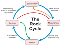
Rock Cycle
The process of transformation of rocks from one form to an other in a cyclic manner is known as the rock cycle. It includes the following processes:
- Hot lava cools down to form igneous rocks.
- These igneous rocks are then broken down into small particles which are transported and then deposited. This results in the formation of sedimentary rocks
- When these igneous and sedimentary rocks are subjected to great heat and pressure, they change into metamorphic rocks.
- These metamorphic rocks under heat and pressure breakdown and form hot lava.
- This hot magma then again cools down and forms igneous rocks.
Posted by Edward Gland 5 years, 5 months ago
- 1 answers
Yogita Ingle 5 years, 5 months ago
The Earth is made up of several layers one inside the other, just like an onion. Following are the main layers of the Earth:
Crust
- The crust is the uppermost layer found on the surface of the Earth.
- It is the thinnest of all the layers and is about 35 km on the continental masses and only about 5 km on the ocean floor.
- Two main mineral constituents of the continental mass are silica and alumina. Therefore, continental crust is also called sial.
- The oceanic crust consists mainly of silica and alumina. Therefore, it is known as sima.
Mantle
- This layer of the Earth lies underneath the crust.
- It extends up to a depth of 2,900 km below the Earth’s crust.
Core
- It is innermost layer of the Earth with a radius of about 3500 km.
- It is called nife as it is made up of nickel and iron (ni-nickle; fe-ferrous or iron).
- There is very high temperature and pressure inside the Earth’s core.
Posted by Teresa Kamei 5 years, 5 months ago
- 1 answers
Yogita Ingle 5 years, 5 months ago
- Pedology is one of the two branches of soil science. The other branch is edaphology.
- Pedology deals with the study of soils. It studies formation of soil, its morphology and classification of soils. The person who studies above aspects is known as pedologist.
Posted by Tikam Singh 5 years, 5 months ago
- 1 answers
Yogita Ingle 5 years, 5 months ago
Some of the direct sources are:-
- Mining: It is a process by which commercially variable valuable mineral resources are extracted from Earth’s surface which includes precious stones, rocks and solid fuels.
- Drilling: Scientists world over are working on two major projects such as “Deep Ocean Drilling Projects” and “Integrated Ocean Drilling Project”. The deepest drill at Kola, in Arctic Ocean, has so far reached a depth of 12 km.
- Volcanic Eruptions: When molten material is thrown onto the surfaced the earth during volcanic eruption it becomes available for analysis
Posted by Mukesh Kumar Panda 5 years, 5 months ago
- 1 answers
Yogita Ingle 5 years, 5 months ago
Body wave -
A body wave is a seismic wave that moves through the interior of the earth, as opposed to surface waves that travel near the earth's surface. P and S waves are body waves. Each type of wave shakes the ground in different ways...
Surface wave -
seismic wave that travels across the surface of the Earth as opposed to through it. Surface waves usually have larger amplitudes and longer wavelengths than body waves, and they travel more slowly than body waves do. Love waves and Rayleigh waves are kinds of surface waves.
Posted by Anushka Kumari 5 years, 5 months ago
- 1 answers
Posted by Siddhi Singhania 5 years, 5 months ago
- 0 answers
Posted by Ravindra Bishnoi 5 years, 5 months ago
- 2 answers
Palak Singh 5 years, 5 months ago
Palak Singh 5 years, 5 months ago
Posted by Buru Yallo 5 years, 5 months ago
- 1 answers
Yogita Ingle 5 years, 5 months ago
1) Indiscriminate deforestation should be prohibited.
2) Wastage of timber and fuel wood to be avoided.
3) Alternative sources of energy, such as biogas should be used to supplement fuel wood.
4) Forest fires should be prevented.
5) Pests and diseases of the forest trees should be controlled chemically and biologically.
6) Grazing of cattle in forests should be discouraged.
7) In discriminate cutting of trees should be prohibited.
8) Reforestation of the deforested areas should be undertaken.
9) Large afforestation should be done in areas unfit for agriculture.
10) Operations called improved cutting and selective cutting should be adopted in forest management
Posted by Buru Yallo 5 years, 5 months ago
- 1 answers
Posted by Gamer Noob 01 5 years, 5 months ago
- 0 answers
Posted by Gamer Noob 01 5 years, 5 months ago
- 1 answers
Madhu Ray 5 years, 4 months ago
Posted by Buru Yallo 5 years, 5 months ago
- 1 answers
Yogita Ingle 5 years, 5 months ago
The major approaches to study geography have been
- Systematic and
- Regional.
Posted by Buru Yallo 5 years, 5 months ago
- 0 answers

myCBSEguide
Trusted by 1 Crore+ Students

Test Generator
Create papers online. It's FREE.
![]()
CUET Mock Tests
75,000+ questions to practice only on myCBSEguide app

Yogita Ingle 5 years, 4 months ago
The name ‘India’ was originated from Indus valley civilization.
Huns, Egyptians, Persians, and other countrymen used to enter India by crossing Indus river. The word Hindu originated from Sindhu. People from these countries used to pronounce S as H and so they called Sindhu as Hindu.
Egyptians and Romans used to call Indus as Sindhu valley and eastern part of it as India.
0Thank You