myCBSEguide App
Download the app to get CBSE Sample Papers 2023-24, NCERT Solutions (Revised), Most Important Questions, Previous Year Question Bank, Mock Tests, and Detailed Notes.
Install NowClass 12 Geography International Trade Extra Questions. myCBSEguide has just released Chapter Wise Question Answers for class 12 Geography. There chapter wise Practice Questions with complete solutions are available for download in myCBSEguide website and mobile app. These Questions with solution are prepared by our team of expert teachers who are teaching grade in CBSE schools for years. There are around 4-5 set of solved Geography Extra Questions from each and every chapter. The students will not miss any concept in these Chapter wise question that are specially designed to tackle Board Exam. We have taken care of every single concept given in CBSE Class 12 Geography syllabus and questions are framed as per the latest marking scheme and blue print issued by CBSE for class 12.
CBSE Class 12 Geography Practice Questions
International Trade Class 12 Extra Questions
India International Trade
- Give share of India’s foreign trade with important partners.
- By which routes does international trade take place in India?
- Why is Marmagao Port called natural port?
- With what objective did British develop ports in India?
- How many ports are there in India at present?
- Explain the hinterland of Kolkata port.
- Give a brief description of Haldia Port and Paradip Port.
- Distinguish between port and harbour.
- Explain the major changes that have occurred in the commodity composition of India’s imports during the period between 1960-2001.
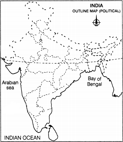
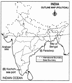
In the given political map of India, locate and label the following with appropriate symbols
- The major sea port located in Odisha.
- The major sea port located in Kerala.

India International Trade
Answer
- According to 2010-11, the share of India’s foreign trade with important partners are UAE(11%), China (10%),USA (7%),Saudi Arabia (4%),Switzerland (4.1%),Hong Kong (3.1%),Germany (3%),Singapore (2.8%),Indonesia (2.6%),Belgium (2.4%) and Korea (2.3%).
- Most of India’s foreign trade is carried through sea ports and air routes. Ports in India handle around 95 per cent of international trade volume of the country. However, a small portion is also carried through land route to neighbouring countries like Nepal, Bhutan, Bangladesh and Pakistan.
- Marmagao Port is called natural port because of its location at the mouth of the Zuari River. The Mormugao port is a crucial component in the flourishing export industry of the state.
- The British used the ports as suction points of the resources from their hinterlands. They used seaport as an entry and exit point for the various cargo which are consumed or produced respectively in the port’s hinterland. For example Kolkata port is one of the largest dry docks of India and also the oldest port that was made by the East India Company.
- At present, India has 12 major sea ports and 200 minor or intermediate ports. The central government’s shipping ministry administers the major ports, the minor and intermediate ports are administered by the relevant departments or ministries in the nine coastal states Andhra Pradesh, Odisha, West Bengal, Tamil Nadu, Kerala, Karnataka, Goa, Maharashtra and Gujarat.
- Hinterland is the influence area which is closely connected to the port with roads and railways. The products of this area are sent to the port for export and imported material is distributed here for sale and consumption. Kolkata Port has a vast hinterland, comprising the entire Eastern India including West Bengal, Bihar, Jharkhand, Uttar Pradesh, Uttarakhand, Madhya Pradesh, Chattisgarh, Punjab, Haryana, Rajasthan, Assam, North Eastern States and the two landlocked neighbouring countries viz. Nepal and Bhutan. The industrial development, commerce and trade of this vast hinterland are inseparably linked to the life and development of Kolkata Port and vice-versa.
- Haldia Port is located 105 km downstream from Kolkata. It has been constructed to reduce the congestion at Kolkata port. It handles bulk cargo like iron ore, coal, petroleum, petroleum products and fertilisers, jute, jute products, cotton and cotton yarn, etc
Paradip Port is situated in the Mahanadi delta, about 100 km from Cuttack. It has the deepest harbour especially suited to handle very large vessels. It has been developed mainly to handle the large-scale export of iron-ore. Orissa, Chhattisgarh and Jharkhand are the parts of its hinterland. Ports Harbours It is the point on the coast where the ship can be tied up for anchoring. It is an area at the sea providing shelter to the ship. It provides facilities for loading and unloading for the ship. Ships are encouraged and given protection from waves and stones. Indented coastline provided natural ports. Rivers with estuaries provide natural resources. It is limited with the fertile and productive hinterland. It provides an adequate room for harbouring of ships. Ports are commercial venues using water facilities. Harbors are more recreational. - The composition of commodities in India’s international trade has been undergoing a change over the years as:
- The share of agriculture and allied products has declined whereas shares of petroleum and crude products and other commodities have increased.
- The shares of ore minerals and manufactured goods have largely remained constant over the years from 1997-98 to 2003-04.
- The increase in the share of petroleum products is due to a rise in petroleum prices as well as an increase in India’s refining capacity.
- The decline in traditional items is largely due to the tough international competition. Amongst the agricultural products, there is a great decline in the exports of traditional items such as coffee, spices, tea, pulses, etc. though an increase has been registered in floricultural products, fresh fruits, marine products and sugar, etc.
- The manufacturing sector alone accounted for 75.96 percent of India’s total value of export in 2003-04.
- Engineering goods have shown significant growth in the export list.
- The textile sector could not achieve much in spite of the liberal measures taken by the government.
- Gems and jewellery contribute a larger share of India’s foreign trade.
-

Chapter Wise Extra Questions for Class 12 Geography
Fundamentals of Human Geography Chapters
- Human Geography Nature and Scope
- The World Population Distribution, Density and Growth
- Population Composition
- Human Development
- Primary Activities
- Secondary Activities
- Tertiary and Quaternary Activities
- Transport and Communication
- International Trade
- Human Settlements
India – People and Economy
- Population: Distribution, Density, Growth and Composition
- Migration: Types, Causes and Consequences
- Human Development
- Human Settlements
- Land Resources and Agriculture
- Water Resources
- Mineral and Energy Resources
- Manufacturing Industries
- Planning and Sustainable Development in Indian Context
- Transport and Communication
- International Trade
- Geographical Perspective on Selected Issues and Problems

Test Generator
Create question paper PDF and online tests with your own name & logo in minutes.
Create Now
myCBSEguide
Question Bank, Mock Tests, Exam Papers, NCERT Solutions, Sample Papers, Notes
Install Now