CBSE Question Paper 2017 Class 12 Geography conducted by Central Board of Secondary Education, New Delhi in the month of March 2017. CBSE previous year question papers with the solution are available in the myCBSEguide mobile app and website. The Best CBSE App for students and teachers is myCBSEguide which provides complete study material and practice papers to CBSE schools in India and abroad.
CBSE Question Paper 2017 Class 12 Geography
Class 12 Geography list of chapters
- Human Geography Nature and Scope
- The World Population Distribution
- Population Composition
- Human Development
- Primary Activities
- Secondary Activities
- Tertiary and Quaternary Activities
- Transport and Communication
- International Trade
- Human Settlements
CBSE Question Paper 2017 Class 12 Geography
General Instructions:
- There are 22 questions in all.
- All questions are compulsory.
- Question numbers 1-7 are very short answer questions carrying 1 mark each. Answer to each of these questions should not exceed 40 words.
- Question numbers 8-13 are short answer questions carrying 3 marks each. Out of which one question is a value based question. Answer to each of these questions should not exceed 80-100 words.
- Question numbers 14-20 are long answer questions carrying 5 marks each. Answer to each of these questions should not exceed 150 words.
- Question numbers 21 and 22 are related to identification or locating and labelling of geographical features on maps carrying 5 marks each.
- Outline maps of the World and India provided to you must be attached within your answer-book.
- Use of templates or stencils for drawing outline maps is allowed.
1. Why is Kobe – Osaka region of Japan very thickly populated ? Give one reason.
2. What is the meaning of empowerment under the concept of human development?
3. Define the term ‘truck farming’.
4. What is an inland seaport?
5. “Rural to Urban migration causes serious environmental problems.” Give an argument to support the statement.
6. “Development is Freedom.” Explain the statement.
7.“Indian railways are highly valuable in bringing the people of diverse cultures together.” Justify.
8. “The physical environment has been greatly modified by human beings, in turn it has also impacted human lives.” Explain the statement.
9. Describe the socio-cultural problems associated with urban settlements in the developing countries.
10. Study the following table carefully and answer the questions that follow :
India – Trends of Urbanisation 1901-2011
| Year | Number of Towns/UAs |
Urban Population (in thousands) |
% of Total Population |
Decennial Growth (%) |
| 1901 | 1,827 | 25,851.9 | 10.84 | – |
| 1911 | 1,815 | 25,941.6 | 10.29 | 0.35 |
| 1921 | 1,949 | 28,086.2 | 11.18 | 8.27 |
| 1931 | 2,072 | 33,456.0 | 11.99 | 19.12 |
| 1941 | 2,250 | 44,153.3 | 13.86 | 31.97 |
| 1951 | 2,843 | 62,443.7 | 17.29 | 41.42 |
| 1961 | 2,365 | 78,936.6 | 17.97 | 26.41 |
| 1971 | 2,590 | 1,09,114 | 19.91 | 38.23 |
| 1981 | 3,378 | 1,59,463 | 23.34 | 46.14 |
| 1991 | 4,689 | 2,17,611 | 25.71 | 36.47 |
| 2001 | 5,161 | 2,85,355 | 27.78 | 31.13 |
| 2011* | 7,935 | 3,77,000 | 31.16 | 31.08 |
(10.1) In which decade the growth rate of urban population was lowest in the country?
(10.2) In which year the decennial growth rate of urban population was the highest?
(10.3) Why is the number of towns growing in India?
Note: The following questions are for the Visually Impaired Candidates only in lieu of Q. No. 10.
(10.1) What is the meaning of urbanization?
(10.2) How is the level of urbanization measured?
(10.3) Explain any one reason for the high growth of urban population in India.
11. Explain the causes of degradation of cultivable land in India.
12. Assess the values of minerals for the social and economic development of India.
13. “The polluted water is a source of various water borne diseases.” Explain.
14. Define age-sex structure. Describe the factors responsible for imbalances in the agesex ratio in different countries of the world.
15. Explain the characteristics of modern large-scale manufacturing in the world.
16. Differentiate between rural marketing centres and urban marketing centres of the world.
17. Study the given map and answer the questions that follow :
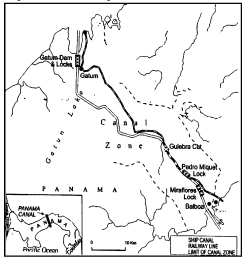
(17.1) Which oceans are connected by the Panama Canal?
(17.2) Name the seaports on either end of this canal.
(17.3) Explain the significance of this canal to the economies of America.
Note: The following questions are for the Visually Impaired Candidates only in lieu of Q. No. 17.
(17.1) Name the country where Panama Canal has been constructed.
(17.2) Name the two oceans connected by this canal.
(17.3) Explain the commercial significance of this canal.
18. Explain the role of climate and physical features on the distribution of population in India.
19. “The conservation and management of water resources is essential for sustainable development in India.” Examine the statement.
20. Study the following table carefully and answer the questions that follow :
Composition of India’s Export, 1997-2011
(Percentage share in Exports)
| Commodities | 1997-98 | 2003-04 | 2009-10 | 2010-11 |
| Agriculture and allied products |
18.93 | 11.8 | 10.0 | 9.9 |
| Ore and Minerals | 3.03 | 3.71 | 4.9 | 4.0 |
| Manufactured goods | 75.83 | 75.96 | 67.4 | 68.0 |
| Crude and petroleum products |
1.01 | 5.59 | 16.2 | 16.8 |
| Other commodities | 1.2 | 2.94 | 1.5 | 1.2 |
(20.1) Which item of export has constantly shown the downward trend?
(20.2) Which item of export by and large remained constant from 1997 to 2011?
(20.3) Explain the causes for the constant upward trend in the exports of crude and petroleum products.
Note: The following questions are for the Visually Impaired Candidates only in lieu of Q.No. 20 :
(20.1) What is the meaning of external trade?
(20.2) Mention any two items for which the export of India is increasing.
(20.3) Explain any three bases of international trade.
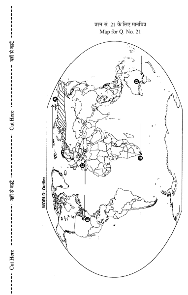
21. Identify the five geographical features shown on the political outline map of the world as A, B, C, D, and E and write their names correctly on the lines marked near them with the help of the following information :
(A) An area of nomadic herding.
(B) An important seaport.
(C) An international airport.
(D) Trans-Continental railway.
(E) An area of very high density of population
Note: The following questions are for the Visually Impaired Candidates only in lieu of Q. No. 21 :
(21.1) Name an area of nomadic herding in Asia.
(21.2) Mention any one major seaport of South Africa.
(21.3) Name an international airport in Italy.
(21.4) Name any one terminal station of transcontinental railway in Australia.
(21.5) Which is the area having very high density of population in U.S.A.?
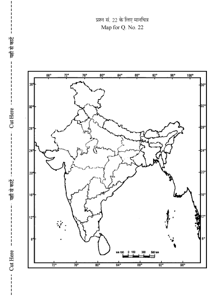
22. Locate and label the following features with appropriate symbols on the given political outline map of India 😐
(i) The state with lowest percentage of urban population.
(ii) The leading tea producing state.
(iii) The integrated steel plant in Odisha.
(iv) The headquarter of South Central Railway Zone.
(v) The city with more than 10 million population in Eastern India.
Note: The following questions are for the Visually Impaired Candidates only in lieu of Q. No. 22 :
(22.1) Name the state of India with lowest level of urbanization.
(22.2) Which is the leading state of India in the production of tea?
(22.3) Name the integrated steel plant located in Odisha.
(22.4) Which is the headquarters of South Central Railway Zone?
(22.5) Name anyone 10 million population city of India.
These are questions only. To view and download complete question paper with solution install myCBSEguide App from google play store or log in to our student dashboard.
Last Year Question Paper Class 12 Geography 2017
Download class 12 Geography paper with the solution from best CBSE App the myCBSEguide. CBSE class 12 Geography question paper 2017 in PDF format with the solution will help you to understand the latest question paper pattern and marking scheme of the CBSE board examination. You will get to know the difficulty level of the question paper.
Previous Year Question Paper for class 12 in PDF
CBSE question papers 2018, 2017, 2016, 2015, 2014, 2013, 2012, 2011, 2010, 2009, 2008, 2007, 2006, 2005 and so on for all the subjects are available under this download link. Practicing real question paper certainly helps students to get confidence and improve performance in weak areas.
- Physics
- Chemistry
- Mathematics
- Biology
- Accountancy
- Business Studies
- Economics
- Geography
- Physical Education
- Computer Science
- Informatics Practices
- English Core
- Hindi Core
- Hindi Elective
- Other Subjects
To download CBSE Question Paper class 12 Accountancy, Chemistry, Physics, History, Political Science, Economics, Geography, Computer Science, Home Science, Accountancy, Business Studies, and Home Science; do check myCBSEguide app or website. myCBSEguide provides sample papers with solution, test papers for chapter-wise practice, NCERT solutions, NCERT Exemplar solutions, quick revision notes for ready reference, CBSE guess papers and CBSE important question papers. Sample Paper all are made available through the best app for CBSE students and myCBSEguide website.
Test Generator
Create question paper PDF and online tests with your own name & logo in minutes.
Create Now
Learn8 App
Practice unlimited questions for Entrance tests & government job exams at ₹99 only
Install Now