CBSE Question Paper 2014 Class 12 Geography conducted by Central Board of Secondary Education, New Delhi in the month of March 2014. CBSE previous year question papers with the solution are available in the myCBSEguide mobile app and website. The Best CBSE App for students and teachers is myCBSEguide which provides complete study material and practice papers to CBSE schools in India and abroad.
CBSE Question Paper 2014 Class 12 Geography
Class 12 Geography list of chapters
- Human Geography Nature and Scope
- The World Population Distribution
- Population Composition
- Human Development
- Primary Activities
- Secondary Activities
- Tertiary and Quaternary Activities
- Transport and Communication
- International Trade
- Human Settlements
CBSE Question Paper 2014 Class 12 Geography
General Instructions:
- There are 26 questions in all.
- All questions are compulsory.
- Marl<s for each question are indicated against it.
- Question numbers I to 10 are very short answer questions carrying 1 mark each. Answer to each of these questions should not exceed 20 words.
- Question numbers 11 to 20 are short answer questions carrying 3 marks each. out of which one question is a value based question. Answer to each of these questions should not exceed 80 words.
- Question numbers 2t to 25 are long answer questions of 5 marks each. Answer to each of these questions should not exceed 750 words.
- Question number 26 is related to identification or locating and labeling of geographical features on mo.ps.
- outline maps of the World and India provided to you must be attached within your answer-book.
- Use of templates or stencils for drawing outline maps is allowed.
1. Define the term ‘quaternary activities.,
2. Give the meaning of ‘digital divide.,
3. Name the seaports on each end of Suez Canal.
4. Define the term ‘road density.’
5. Give any two examples of ancient towns of India.
6. Name the country which is the largest trading partner of India.
7. Name the seaport which was constructed to reduce the congestion at Kolkata port.
8. Name the major seaport which was developed just after independence on the western coast of India.
9. What is truck farming?
10. Mention the root cause of ‘acid rains’.
11.”There is mutual interaction between the elements of Physical Geography and Human Geography.” Support the statement with suitable examples.
12. Describe any three characteristics of ‘Household Industries.’
13.Study the map given below and answer the questions that follow:
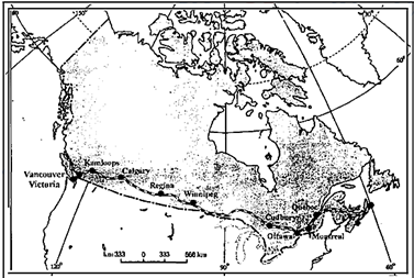
(13.1) Name the railway line shown on this map.
(13.2) Name the terminal station of this railway along the Atlantic Coast.
(13.3) Why is this railway line known as ‘economic artery’ of the country through which it passes?
14. Differentiate between rural and urban settlements of India in three points.
15. State any two characteristics each of the three distinct ‘cropping seasons’ of India.
16. Explain any three main characteristics of mineral resources of India.
17. Describe any three advantages of satellite communication in India.
18. Why is the ‘Urban Waste Disposal’ a serious problem in India? Explain any three reasons.
19.Study the diagram given below, showing the location of an important steel plant of India and answer the questions that follow:
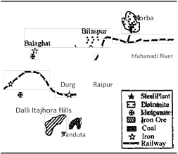
(19.1) Identify the steel plant and name it.
(19.2) Mention the thermal power plant which supplies power to it.
(19.3) Mention the source of water for this plant.
Note: The following questions are for the Visually Impaired candidates only; in
lieu of Q. No. 19.
(19.1) which steel plant was established with Russian collaboration in Chhattisgarh?
(19.2) Name the thermal power plant which supplies power to this plant.
(19.3) Mention the source of water for this plant.
20.Analyse the economic and social values of rainwater harvesting.
21. Explain the three components of population change in the word. Analyze the impacts of population change.
22. Describe any five characteristics of, Commercial Livestock Rearing, practiced in the World.
23. Differentiate between bilateral trade and multilateral trade. Explain how ports are helpful in trade.
24. Describe any five patterns of ruml settlements in the world on the basis of forms or shapes.
25.”The decades 1921-51 are referred to as the period of steady growth of population whereas the decades 1951-1991 are referred to as the period of population explosion in India.” Explain giving reasons.
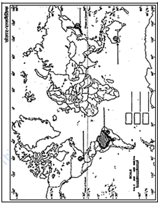
26. (26.1) In the given political outline Map of the World, four features A, B, C, and D have been shown. Identify these features with the help of information given below and write their correct names on the lines drawn near them.
A: An important seaport
B: A terminal station of Australian Trans-Continental Railway
C: An area of subsistence gathering
D: The country with lowest growth rate of population (1995-2000) in Asia.
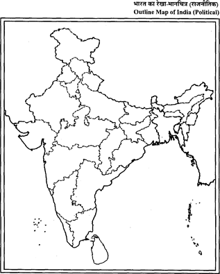
(26.2) On the given political outline Map of India, locate and label the following with appropriate symbols:
A. The state having highest literacy rate.
B. The leading state in the production of Jute.
C. The northernmost international airport.
Note: The following questions are for the Visually Impaired candidates only; in lieu of
Q. No. 26:
(26.1) Mention an area of subsistence gathering in South America.
(26.2) Name the country with lowest growth rate of population (1995-2000) in Asia.
(26.3) Which state has highest literacy rate in India?
(26.4) Name the leading state in the production of Jute in India.
(26.5) Name the northernmost international airport of India.
These are questions only. To view and download complete question paper with solution install myCBSEguide App from google play store or log in to our student dashboard.
Last Year Question Paper Class 12 Geography 2014
Download class 12 Geography paper with the solution from best CBSE App the myCBSEguide. CBSE class 12 Geography question paper 2014 in PDF format with the solution will help you to understand the latest question paper pattern and marking scheme of the CBSE board examination. You will get to know the difficulty level of the question paper.
Previous Year Question Paper for class 12 in PDF
CBSE question papers 2018, 2017, 2016, 2015, 2014, 2013, 2012, 2011, 2010, 2009, 2008, 2007, 2006, 2005 and so on for all the subjects are available under this download link. Practicing real question paper certainly helps students to get confidence and improve performance in weak areas.
- Physics
- Chemistry
- Mathematics
- Biology
- Accountancy
- Business Studies
- Economics
- Geography
- Physical Education
- Computer Science
- Informatics Practices
- English Core
- Hindi Core
- Hindi Elective
- Other Subjects
To download CBSE Question Paper class 12 Accountancy, Chemistry, Physics, History, Political Science, Economics, Geography, Computer Science, Home Science, Accountancy, Business Studies, and Home Science; do check myCBSEguide app or website. myCBSEguide provides sample papers with solution, test papers for chapter-wise practice, NCERT solutions, NCERT Exemplar solutions, quick revision notes for ready reference, CBSE guess papers and CBSE important question papers. Sample Paper all are made available through the best app for CBSE students and myCBSEguide website.
Test Generator
Create question paper PDF and online tests with your own name & logo in minutes.
Create Now
Learn8 App
Practice unlimited questions for Entrance tests & government job exams at ₹99 only
Install Now