CBSE Question Paper 2007 Class 12 Geography conducted by Central Board of Secondary Education, New Delhi in the month of March 2007. CBSE previous year question papers with the solution are available in the myCBSEguide mobile app and website. The Best CBSE App for students and teachers is myCBSEguide which provides complete study material and practice papers to CBSE schools in India and abroad.
CBSE Question Paper 2007 Class 12 Geography
Class 12 Geography list of chapters
- Human Geography Nature and Scope
- The World Population Distribution
- Population Composition
- Human Development
- Primary Activities
- Secondary Activities
- Tertiary and Quaternary Activities
- Transport and Communication
- International Trade
- Human Settlements
CBSE Question Paper 2007 Class 12 Geography
General Instructions :
- There are 19 general questions.
- All questions are compulsory.
- Marks for each question are indicated against it.
- Questions number 1 to 10 are short-answer questions carrying 3 marks each. Answer to each of these questions should not exceed 80 words.
- Questions number 11 to 15 are also short-answer questions of 4 marks each. Answer to each of these questions should not exceed 120 words.
- Questions number 16, 17 and 18 are long-answer questions of 5 marks each. Answer to each of these questions should not exceed 150 words.
- Question number 19 contains test items of very short-answers. It is of 5 marks.
- Outline maps of the World and India provided to you must be attached with your answer-book.
- Use of templates or stencils for drawing outline maps is allowed.
1. Who was the writer of the book ‘Geographia Generalis’? State two branches of geography according to this writer.
2. Name the three groups of resources based on the content and give one example of each group.
3. Why is iron most widely used in the world, in comparison with other metals? Explain three reasons.
4. Explain with examples the three major physical factors which affect the crop distribution in the world.
5. How does ‘specialisation’ in the production of goods and services promote international trade in the world? Explain with three suitable examples.
6. Explain any three major problems faced by Indian farmers in drylands.
7. “There is marked regional disparity in the levels of development in India”. Support this statement with any three suitable examples.
8. Study the map given below and answer the questions that follow :
| Length of Roads (000 km) All |
1950-51 |
1980-81 |
1996-97 |
|
400 |
1419 |
2465.9 |
|
| Surfaced |
157.0 |
684.0 |
1394.1 |
| National Highways |
19.8 |
31.7 |
34.8 |
| State Highways |
NA |
94.4 |
137.1 |
| Number of Registered Vehicles (000)
All |
306 |
5391 |
37231 |
| Goods Vehicles (000) |
82 |
554 |
2260 |
| Buses |
34 |
162 |
488 |
(8.1) Which type of roads shows the highest increase during the period
(8.2) between 1950-51 and 1996-97? How much has it increased? Explain two reasons responsible for the increase in this type of roads.
Note: The following question is for the BLIND CANDIDATES only in lieu of Q. No. 8.
State any three main features of ‘Border Roads’.
9. Study the map given below and answer the questions that follow :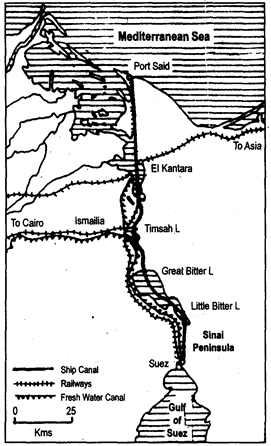
(9.1) Name the canal shown in the map. In which country is it located?
(9.2) Name the two seas connected by this canal.
(9.3) Name any two lakes through which this canal passes.
Note: The following question is for the Blind Candidates only in lieu of Q. No. 9.
State three main features of ‘Panama Canal’.
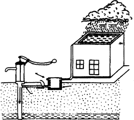
10. Study the diagram given below and answer the questions that follow :
(10.1) Give a suitable title to the given diagram.
(10.2) How is rainwater harvested through this technique? Explain.
Note: The following question is for the Blind Candidates only in lieu of Q. No. 10.
What is rainwater harvesting? State any four objectives of rainwater harvesting.
11. Write any two main characteristics each of the four different modes of transport in the world.
12. Describe any four major human-made sources of air pollution in India.
13. Explain any four differences between rural and urban settlements in India.
14. Classify the means of communication of India into two groups. Explain three points of importance of each group.
15. Study the table given below and answer the questions that follow :
Global Land Use Changes (Area in Million Hectares)
| Broad Land Uses |
1700 |
1850 |
1920 |
1950 |
1.980 |
2000* |
| Forests |
6214 |
5965 |
5678 |
5389 |
5053 |
3454 |
| Grasslands |
6860 |
6837 |
6748 |
6780 |
6788 |
3427 |
| Croplands |
265 |
537 |
913 |
1170 |
1501 |
1512 |
(15.1) Under which land use category the smallest area of land is being used? Explain one reason for it.
(15.2) Name the land use category in which the area is continuously decreasing. Explain due reason for it.
(15.3) Explain the main reason for the continuous increase of cropland area.
Note: The following question is for the Blind Candidates only in lieu of Q. No. 15.
Explain any four features of commercial agriculture practiced in the world.
16. What are rural settlements? Which are the two distinct patterns of rural settlements of the world based on the form? Describe three main features of each.
17. What is the meaning of population growth? Describe two main features each of the four phases of Indian demographic history.
18. How do the physical factors play a dominant role in the distribution and density of population on the earth’s surface? Explain any five factors with suitable examples.
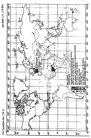
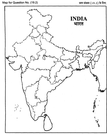
19. (19.1) In the given political outline map of the world, four features are shown as A, B, C and D. Identify them with the help of the map legend and write their correct names on the dotted lines marked on the map.
(19.2) On the given political outline map of India provided to you, locate and
label the following with appropriate symbols :
(i) The least populated state,
(ii) The biggest oil refinery in the country,
(iii) Iron and steel plant located in Chhattisgarh.
Note: The following question is for the Blind Candidates only in lieu
of Q. No. 19. 5×1=5
(19.1) Name the most populated country of Africa.
(19.2) Which is the largest wheat producing country of Europe?
(19.3) Which is the least populated state of India?
(19.4) Name the biggest oil refinery of our country.
(19.5) Name the iron and steel plant located in Chhattisgarh.
These are questions only. To view and download complete question paper with solution install myCBSEguide App from google play store or log in to our student dashboard.
Last Year Question Paper Class 12 Geography 2007
Download class 12 Geography paper with the solution from best CBSE App the myCBSEguide. CBSE class 12 Geography question paper 2007 in PDF format with the solution will help you to understand the latest question paper pattern and marking scheme of the CBSE board examination. You will get to know the difficulty level of the question paper.
Previous Year Question Paper for class 12 in PDF
CBSE question papers 2018, 2017, 2016, 2015, 2014, 2013, 2012, 2011, 2010, 2009, 2008, 2007, 2006, 2005 and so on for all the subjects are available under this download link. Practicing real question paper certainly helps students to get confidence and improve performance in weak areas.
- Physics
- Chemistry
- Mathematics
- Biology
- Accountancy
- Business Studies
- Economics
- Geography
- Physical Education
- Computer Science
- Informatics Practices
- English Core
- Hindi Core
- Hindi Elective
- Other Subjects
To download CBSE Question Paper class 12 Accountancy, Chemistry, Physics, History, Political Science, Economics, Geography, Computer Science, Home Science, Accountancy, Business Studies, and Home Science; do check myCBSEguide app or website. myCBSEguide provides sample papers with solution, test papers for chapter-wise practice, NCERT solutions, NCERT Exemplar solutions, quick revision notes for ready reference, CBSE guess papers and CBSE important question papers. Sample Paper all are made available through the best app for CBSE students and myCBSEguide website.
Test Generator
Create question paper PDF and online tests with your own name & logo in minutes.
Create Now
Learn8 App
Practice unlimited questions for Entrance tests & government job exams at ₹99 only
Install Now